
Petah Tikva topographic map
Interactive map
Click on the map to display elevation.
About this map
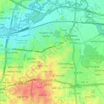
Name: Petah Tikva topographic map, elevation, terrain.
Location: Petah Tikva, Petah Tikva Subdistrict, Center District, Israel (32.05413 34.84580 32.12715 34.92909)
Average elevation: 121 ft
Minimum elevation: 26 ft
Maximum elevation: 308 ft
Other topographic maps
Click on a map to view its topography, its elevation and its terrain.
Bat Hefer
Israel > Center District > Emek Hefer Regional Council > Bat Hefer
Average elevation: 187 ft
Modiin-Maccabim-Reut
Israel > Center District > Ramla Subdistrict > Modiin-Maccabim-Reut
Average elevation: 787 ft