
Graysville topographic map
Interactive map
Click on the map to display elevation.
About this map
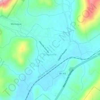
Name: Graysville topographic map, elevation, terrain.
Average elevation: 850 ft
Minimum elevation: 692 ft
Maximum elevation: 1,476 ft
Rhea County trails, hiking, mountain biking, running and outdoor activities
Other topographic maps
Click on a map to view its topography, its elevation and its terrain.
Mountain View
United States > Tennessee > Rhea County > Dayton > Mountain View
Average elevation: 906 ft