
Green Township topographic map
Interactive map
Click on the map to display elevation.
About this map
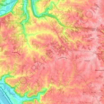
Name: Green Township topographic map, elevation, terrain.
Location: Green Township, Hamilton County, Ohio, 45248, United States (39.11865 -84.69049 39.21096 -84.57142)
Average elevation: 801 ft
Minimum elevation: 459 ft
Maximum elevation: 951 ft
Hamilton County trails, hiking, mountain biking, running and outdoor activities
Other topographic maps
Click on a map to view its topography, its elevation and its terrain.
French Park
United States > Ohio > Hamilton County > Amberley Village > Rolling Knolls Estate
Average elevation: 771 ft
Nature Center at The Summit
United States > Ohio > Hamilton County > Cincinnati
Average elevation: 568 ft
Cincinnati
United States > Ohio > Hamilton County
Cincinnati has several standard modes of transportation including sidewalks, roads, public transit, bicycle paths and airports. The city's hills preclude the regular street grid common to many cities built up in the 19th century, and outside of the downtown basin, regular street grids are rare except for in…
Average elevation: 738 ft