
Shennongjia topographic map
Interactive map
Click on the map to display elevation.
Shennongjia
Shennongjia Forestry District is named after the Shennongjia mountainous massif, which is usually considered to be the eastern (and the highest) section of the Daba Mountains (Daba Shan). It lies within the Daba Mountains evergreen forests ecoregion. Some of Hubei's highest mountains - which are also the highest mountains of the Daba Shan - are located within the district. The three tallest peaks, located west of Muyu town, are Shennong Deng (3,105 metres (10,187 ft) elevation), Da Shennongjia (3,052 metres (10,013 ft)), and Xiao Shennongjia (3,005 metres (9,859 ft), on the border with Badong County). Laojun Shan, 2,936 metres (9,633 ft) tall, is located northeast of Muyu.
About this map
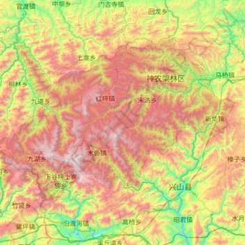
Name: Shennongjia topographic map, elevation, terrain.
Location: Shennongjia, Hubei, China (31.29862 109.93621 31.86261 110.97283)
Average elevation: 4,199 ft
Minimum elevation: 459 ft
Maximum elevation: 10,062 ft
Other topographic maps
Click on a map to view its topography, its elevation and its terrain.
Wuhan Botanical Garden, Chinese Academy of Sciences
China > Hubei > Hongshan District
Average elevation: 95 ft
Yuxi
China > Hubei > Yichang > Yuxi
Tempered by the low latitude and moderate elevation, Yuxi has a mild subtropical highland climate (Köppen Cwb), with short, mild, dry winters, and warm, rainy summers. Frost may occur in winter but the days still generally warm up to around 17 °C (63 °F). During summer, a majority of the days features some…
Average elevation: 217 ft