
Erie topographic map
Interactive map
Click on the map to display elevation.
About this map
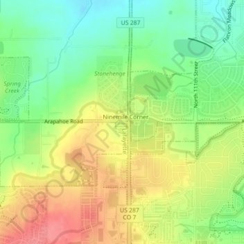
Name: Erie topographic map, elevation, terrain.
Location: Erie, Boulder County, Colorado, United States (40.01320 -105.10491 40.01605 -105.10311)
Average elevation: 5,240 ft
Minimum elevation: 5,125 ft
Maximum elevation: 5,367 ft
Boulder County trails, hiking, mountain biking, running and outdoor activities
Other topographic maps
Click on a map to view its topography, its elevation and its terrain.
Lafayette
United States > Colorado > Boulder County > Lafayette > Lafayette
Average elevation: 5,240 ft
Longs Peak
United States > Colorado > Boulder County
Together with nearby Mount Meeker, with an elevation of 13,911 feet, the two mountains are sometimes referred to as the Twin Peaks (not to be confused with a nearby lower mountain called Twin Sisters).
Average elevation: 12,549 ft
Boulder
United States > Colorado > Boulder County > Boulder
Boulder is located at the base of the foothills of the Rocky Mountains, at an elevation of 5,430 feet (1,655 m) above sea level. Boulder is 25 miles (40 km) northwest of the Colorado State Capitol in Denver. It is home of the main campus of the University of Colorado, the state's largest university.
Average elevation: 6,486 ft
Gunbarrel
United States > Colorado > Boulder County
Gunbarrel is northeast of the city of Boulder proper, separated by a buffer area of private agricultural lands and publicly owned open space. The buffer areas provide over two miles (3 km) of separation over changing elevations. This reduces the impact of the Boulder Municipal Airport and the Boulder County…
Average elevation: 5,171 ft
Seven Hills
United States > Colorado > Boulder County > Boulder > Seven Hills
Average elevation: 6,512 ft