
Paramus topographic map
Interactive map
Click on the map to display elevation.
Paramus
Farview Avenue, located at the highest elevation in Paramus, has a clear view of the Manhattan skyline.
About this map
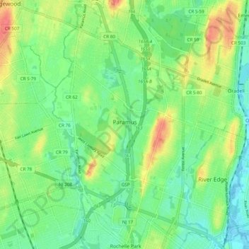
Name: Paramus topographic map, elevation, terrain.
Location: Paramus, Bergen County, New Jersey, United States (40.90853 -74.10138 40.98064 -74.03873)
Average elevation: 75 ft
Minimum elevation: 7 ft
Maximum elevation: 194 ft
Bergen County trails, hiking, mountain biking, running and outdoor activities
Other topographic maps
Click on a map to view its topography, its elevation and its terrain.
Hillsdale
United States > New Jersey > Bergen County > Hillsdale > Hillsdale
Average elevation: 131 ft
Ridgefield Park
United States > New Jersey > Bergen County > Ridgefield Park > Ridgefield Park
Average elevation: 69 ft
Glen Rock
United States > New Jersey > Bergen County > Glen Rock > Glen Rock
Average elevation: 171 ft