
Make a donation
Gear up for your next adventure:
As an Amazon Associate, this site earns from qualifying purchases at no extra cost to you.
Spirit Lake topographic map
Click on the map to display elevation.
Make a donation
Gear up for your next adventure:
As an Amazon Associate, this site earns from qualifying purchases at no extra cost to you.
Spirit Lake
Spirit Lake is located at 47°58′00″N 116°51′59″W / 47.966592°N 116.866383°W / 47.966592; -116.866383, at an elevation of 2,569 feet (783 m) above sea level.
Make a donation
Gear up for your next adventure:
As an Amazon Associate, this site earns from qualifying purchases at no extra cost to you.
About this map
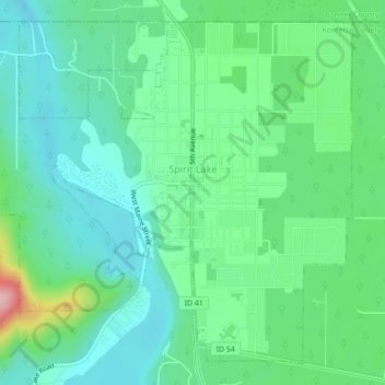
Name: Spirit Lake topographic map, elevation, terrain.
Location: Spirit Lake, Kootenai County, Idaho, 83869, United States (47.95155 -116.89394 47.97742 -116.85044)
Average elevation: 2,559 ft
Minimum elevation: 2,411 ft
Maximum elevation: 2,982 ft
Kootenai County trails, hiking, mountain biking, running and outdoor activities
Make a donation
Gear up for your next adventure:
As an Amazon Associate, this site earns from qualifying purchases at no extra cost to you.
Other topographic maps
Click on a map to view its topography, its elevation and its terrain.
Make a donation
Gear up for your next adventure:
As an Amazon Associate, this site earns from qualifying purchases at no extra cost to you.
Bayview
United States > Idaho > Kootenai County
Bayview is an unincorporated community in the northwest United States, located in Kootenai County, Idaho, north of Coeur d'Alene. On the southwest shore of Lake Pend Oreille, Bayview is seven miles (11 km) east-northeast of Athol. The community is served by State Highway 54 and a post office with ZIP code…
Average elevation: 2,405 ft