
Logsden topographic map
Interactive map
Click on the map to display elevation.
About this map
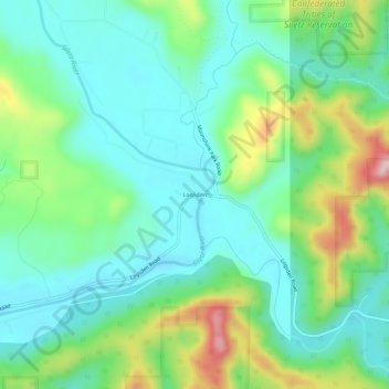
Name: Logsden topographic map, elevation, terrain.
Location: Logsden, Lincoln County, Oregon, United States (44.72288 -123.81319 44.76288 -123.77319)
Average elevation: 390 ft
Minimum elevation: 148 ft
Maximum elevation: 1,004 ft
Lincoln County trails, hiking, mountain biking, running and outdoor activities
Other topographic maps
Click on a map to view its topography, its elevation and its terrain.
Lincoln Beach
United States > Oregon > Lincoln County
Lincoln Beach is located in northwestern Lincoln County at 44°52′20″N 124°02′12″W / 44.872092°N 124.036591°W / 44.872092; -124.036591, between Lincoln City to the north and Depoe Bay to the south. It is bordered to the west by the Pacific Ocean. Lincoln Beach proper is in the southern part…
Average elevation: 98 ft