
Downingtown topographic map
Interactive map
Click on the map to display elevation.
About this map
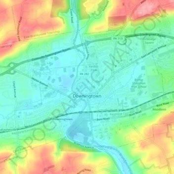
Name: Downingtown topographic map, elevation, terrain.
Average elevation: 348 ft
Minimum elevation: 210 ft
Maximum elevation: 594 ft
Chester County trails, hiking, mountain biking, running and outdoor activities
Other topographic maps
Click on a map to view its topography, its elevation and its terrain.
Baptism Creek Spring
United States > Pennsylvania > Chester County > North Coventry Township
Average elevation: 748 ft
Nottingham County Park
United States > Pennsylvania > Chester County > West Nottingham Township
Average elevation: 449 ft
Longwood Gardens
United States > Pennsylvania > Chester County > East Marlborough Township
Average elevation: 410 ft
Whitehorse
United States > Pennsylvania > Chester County > Willistown Township
Average elevation: 384 ft
East Nantmeal
United States > Pennsylvania > Chester County > East Nantmeal Township
Average elevation: 646 ft
Reeceville
United States > Pennsylvania > Chester County > West Brandywine Township
Average elevation: 554 ft
Ship Road
United States > Pennsylvania > Chester County > West Whiteland Township > Exton
Average elevation: 436 ft
Valley Forge
United States > Pennsylvania > Chester County > Schuylkill Township
Average elevation: 256 ft
Nottingham
United States > Pennsylvania > Chester County > West Nottingham Township
Average elevation: 476 ft
Grove
United States > Pennsylvania > Chester County > West Whiteland Township
Average elevation: 420 ft
Martins Corner
United States > Pennsylvania > Chester County > West Caln Township
Average elevation: 696 ft
Nottingham
United States > Pennsylvania > Chester County > West Nottingham Township > Nottingham
Average elevation: 476 ft
Paoli
United States > Pennsylvania > Chester County > Tredyffrin Township > Paoli
Average elevation: 420 ft
Chester Springs
United States > Pennsylvania > Chester County > West Pikeland Township
Average elevation: 367 ft