
Downingtown topographic map
Click on the map to display elevation.
About this map
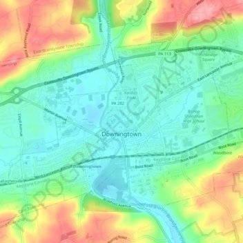
Name: Downingtown topographic map, elevation, terrain.
Average elevation: 348 ft
Minimum elevation: 210 ft
Maximum elevation: 594 ft
Chester County trails, hiking, mountain biking, running and outdoor activities
Other topographic maps
Click on a map to view its topography, its elevation and its terrain.
Strafford
United States > Pennsylvania > Chester County > Tredyffrin Township
Average elevation: 436 ft
Longwood Gardens
United States > Pennsylvania > Chester County > East Marlborough Township
Average elevation: 410 ft
Woodwards Corner
United States > Pennsylvania > Chester County > West Bradford Township
Average elevation: 469 ft
Nottingham County Park
United States > Pennsylvania > Chester County > West Nottingham Township
Average elevation: 449 ft
Valley Forge
United States > Pennsylvania > Chester County > Schuylkill Township
Average elevation: 256 ft
Bondsville
United States > Pennsylvania > Chester County > East Brandywine Township
Average elevation: 492 ft
Pikeland
United States > Pennsylvania > Chester County > West Pikeland Township > Chester Springs
Average elevation: 351 ft
Strickersville
United States > Pennsylvania > Chester County > London Britain Township
Average elevation: 308 ft
Nottingham
United States > Pennsylvania > Chester County > West Nottingham Township
Average elevation: 476 ft
Wagontown
United States > Pennsylvania > Chester County > West Caln Township
Average elevation: 545 ft
East Nantmeal
United States > Pennsylvania > Chester County > East Nantmeal Township
Average elevation: 646 ft
Freemont
United States > Pennsylvania > Chester County > West Nottingham Township
Average elevation: 377 ft
Knickerbocker
United States > Pennsylvania > Chester County > Willistown Township
Average elevation: 417 ft
Mount Misery
United States > Pennsylvania > Chester County > Tredyffrin Township
Average elevation: 338 ft
Chadds Ford Junction
United States > Pennsylvania > Chester County > Pennsbury Township
Average elevation: 276 ft
Pomeroy
United States > Pennsylvania > Chester County > Sadsbury Township > Sadsburyville
Average elevation: 574 ft
Hayti
United States > Pennsylvania > Chester County > Valley Township
Hayti is a census designated place and unincorporated community situated in Valley Township in Chester County, Pennsylvania, United States. The CDP was first designated as such in 2020. As of 2020, it has a population of 2,890. Hayti has an estimated elevation of 502 feet (153 m) above sea level.
Average elevation: 495 ft
Maple Grove
United States > Pennsylvania > Chester County > East Nottingham Township
Average elevation: 446 ft
Exton
United States > Pennsylvania > Chester County > West Whiteland Township
Average elevation: 410 ft
Reeceville
United States > Pennsylvania > Chester County > West Brandywine Township
Average elevation: 554 ft
Baptism Creek Spring
United States > Pennsylvania > Chester County > North Coventry Township
Average elevation: 748 ft
Valley Forge
United States > Pennsylvania > Chester County > Schuylkill Township
Average elevation: 256 ft
Grove
United States > Pennsylvania > Chester County > West Whiteland Township
Average elevation: 420 ft
Martins Corner
United States > Pennsylvania > Chester County > West Caln Township
Average elevation: 696 ft
Saint Peters
United States > Pennsylvania > Chester County > Warwick Township
Average elevation: 515 ft
Ship Road
United States > Pennsylvania > Chester County > West Whiteland Township > Exton
Average elevation: 436 ft
Whitehorse
United States > Pennsylvania > Chester County > Willistown Township
Average elevation: 384 ft
Barnsley
United States > Pennsylvania > Chester County > East Nottingham Township
Average elevation: 509 ft
Baptist Hill
United States > Pennsylvania > Chester County > Tredyffrin Township
Average elevation: 335 ft
Copesville
United States > Pennsylvania > Chester County > East Bradford Township
Average elevation: 302 ft
Paoli
United States > Pennsylvania > Chester County > Tredyffrin Township > Paoli
Average elevation: 420 ft
Nottingham
United States > Pennsylvania > Chester County > West Nottingham Township > Nottingham
Average elevation: 476 ft