Geolocate

Winchester topographic map

Interactive map

Click on the map to display elevation.

About this map

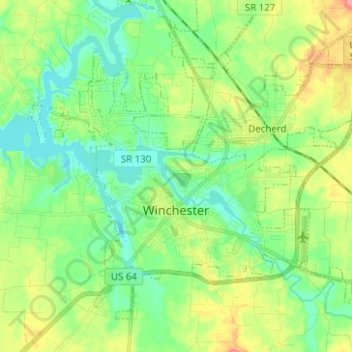
Name: Winchester topographic map, elevation, terrain.

Location: Winchester, Franklin County, Middle Tennessee, Tennessee, United States (35.15427 -86.16458 35.23758 -86.03991)

Average elevation: 961 ft

Minimum elevation: 873 ft

Maximum elevation: 1,135 ft

Franklin County trails, hiking, mountain biking, running and outdoor activities

Other topographic maps

Click on a map to view its topography, its elevation and its terrain.

Henley

United States > Tennessee > Franklin County > Decherd

Average elevation: 961 ft

Asia

United States > Tennessee > Franklin County

Average elevation: 974 ft

Midway

United States > Tennessee > Franklin County

Average elevation: 1,900 ft

Broadview

United States > Tennessee > Franklin County

Average elevation: 965 ft

Beech Hill

United States > Tennessee > Franklin County

Average elevation: 919 ft

Shady Grove

United States > Tennessee > Franklin County

Average elevation: 991 ft

Sewanee

United States > Tennessee > Franklin County

Average elevation: 1,680 ft

Belvidere

United States > Tennessee > Franklin County

Average elevation: 1,014 ft