
Confluence topographic map
Interactive map
Click on the map to display elevation.
About this map
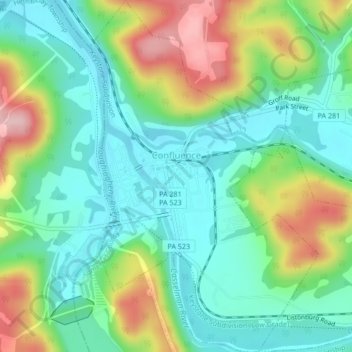
Name: Confluence topographic map, elevation, terrain.
Average elevation: 1,506 ft
Minimum elevation: 1,289 ft
Maximum elevation: 1,946 ft
Somerset County trails, hiking, mountain biking, running and outdoor activities
Other topographic maps
Click on a map to view its topography, its elevation and its terrain.
Zimmerman
United States > Pennsylvania > Somerset County > Somerset Township
Average elevation: 2,142 ft
2768 feet
United States > Pennsylvania > Somerset County > Jefferson Township
Average elevation: 2,661 ft
Mount Davis
United States > Pennsylvania > Somerset County > Elk Lick Township
Mount Davis has a humid continental climate that is affected by the high elevation significantly enough that the area feels slightly more like a cooler version of the climate zone during the winter months. Due to its high elevation, the area is colder much of the winter than Altoona, Johnstown, or State…
Average elevation: 2,972 ft