
Seminole topographic map
Interactive map
Click on the map to display elevation.
Seminole
Seminole features predominantly flat terrain with an average elevation of approximately 36 feet (11 meters) above sea level. The area is characterized by its proximity to the Gulf of Mexico, which significantly influences its landscape and climate. Surrounding Seminole are a mix of residential neighborhoods, parks, and natural preserves, with some areas featuring low-lying wetlands and coastal ecosystems. The flat topography is typical of the region, contributing to its accessibility and fostering a suburban atmosphere, while nearby beaches and waterfronts provide recreational opportunities. The landscape is also interspersed with small lakes and ponds, enhancing its natural beauty and biodiversity.
About this map
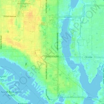
Name: Seminole topographic map, elevation, terrain.
Location: Seminole, Pinellas County, Florida, 33772, United States (27.80937 -82.81703 27.87583 -82.75384)
Average elevation: 30 ft
Minimum elevation: -13 ft
Maximum elevation: 85 ft
Pinellas County trails, hiking, mountain biking, running and outdoor activities
Other topographic maps
Click on a map to view its topography, its elevation and its terrain.
Fort De Soto County Park
United States > Florida > Pinellas County > Saint Petersburg
Average elevation: 0 ft
Boyd Hill Nature Preserve
United States > Florida > Pinellas County > Saint Petersburg > Lakewood Estates
Average elevation: 23 ft
Boyd Hill Nature Preserve
United States > Florida > Pinellas County > Saint Petersburg > Lakewood Estates
Average elevation: 23 ft
Splash Harbour Water Park
United States > Florida > Pinellas County > Indian Rocks Beach
Average elevation: 13 ft
Lealman
United States > Florida > Pinellas County
Lealman is located at 27°49′10″N 82°41′4″W / 27.81944°N 82.68444°W / 27.81944; -82.68444 (27.8197, -82.6846). The community is bordered by the city of Pinellas Park to the north, St. Petersburg to the east and south, and by the town of West Lealman to the west. The elevation is 49 feet (15…
Average elevation: 43 ft
Middle Tampa Bay
United States > Florida > Pinellas County > Saint Petersburg
Average elevation: 13 ft
Frenchman's Creek
United States > Florida > Pinellas County > Saint Petersburg
Average elevation: 13 ft
Lakewood Estates
United States > Florida > Pinellas County > Saint Petersburg
Average elevation: 23 ft
Acklocknayke (historical)
United States > Florida > Pinellas County > Palm Harbor
Average elevation: 10 ft
Honeymoon Island Dog Beach
United States > Florida > Pinellas County > Palm Harbor
Average elevation: 0 ft
Saint Petersburg
United States > Florida > Pinellas County > Saint Petersburg
Average elevation: 10 ft