
Gandia topographic map
Interactive map
Click on the map to display elevation.
About this map
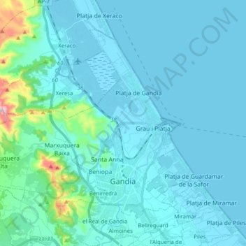
Name: Gandia topographic map, elevation, terrain.
Location: Gandia, la Safor, Valencia, Valencian Community, Spain (38.94981 -0.29715 39.04128 -0.14424)
Average elevation: 164 ft
Minimum elevation: -7 ft
Maximum elevation: 1,837 ft
Other topographic maps
Click on a map to view its topography, its elevation and its terrain.
Coma Breco
Spain > Valencian Community > el Poble Nou de Benitatxell / Benitachell
Average elevation: 482 ft
Raiguero de Bonanza
Spain > Valencian Community > el Baix Segura / La Vega Baja > Orihuela
Average elevation: 456 ft
Playa Flamenca I
Spain > Valencian Community > el Baix Segura / La Vega Baja del Segura > Orihuela > Urbanización La Zenia
Average elevation: 82 ft
Cap de la Nau
Spain > Valencian Community > Xàbia / Jávea
Atop the headland, at an elevation of 120 metres (390 ft), stands the Cap de la Nau lighthouse, providing an important aid to navigation.
Average elevation: 105 ft
Cabo Roig
Spain > Valencian Community > el Baix Segura / La Vega Baja del Segura > Orihuela
Average elevation: 30 ft
Platja del Cabanyal - Les Arenes
Spain > Valencian Community > Comarca de València > Valencia
Average elevation: 7 ft
la Garrotxa
Spain > Valencian Community > Castelló / Castellón > Cervera del Maestre
Average elevation: 896 ft
Dehesa de Campoamor
Spain > Valencian Community > el Baix Segura / La Vega Baja del Segura > Orihuela
Average elevation: 92 ft
Urbanización Doña Pepa
Spain > Valencian Community > el Baix Segura / La Vega Baja del Segura > Rojales
Average elevation: 79 ft
Vila-real
Spain > Valencian Community > Castelló / Castellón > Vila-real > Vila-real
Average elevation: 138 ft
Dehesa de Campoamor
Spain > Valencian Community > Orihuela > Dehesa de Campoamor
Average elevation: 144 ft
El Pinar de Campoverde
Spain > Valencian Community > el Baix Segura / La Vega Baja del Segura > Pilar de la Horadada
Average elevation: 440 ft
Bassa de Ferrara
Spain > Valencian Community > Castelló / Castellón > la Pobla Tornesa
Average elevation: 1,565 ft
Balcón de la Costa Blanca
Spain > Valencian Community > el Baix Segura / La Vega Baja del Segura > San Miguel de Salinas > Balcón de la Costa Blanca
Average elevation: 240 ft
Torre de la Horadada
Spain > Valencian Community > el Baix Segura / La Vega Baja del Segura > Pilar de la Horadada
Average elevation: 16 ft
Plaza Antigua Fábrica Fernando Diago
Spain > Valencian Community > Castelló / Castellón > Castelló de la Plana
Average elevation: 115 ft
Villa Martín
Spain > Valencian Community > el Baix Segura / La Vega Baja del Segura > Orihuela > Villa Martín
Average elevation: 243 ft