
Ryegate topographic map
Interactive map
Click on the map to display elevation.
Ryegate
According to the United States Census Bureau, the town has a total area of 36.8 square miles (95.2 km2), of which 36.5 square miles (94.5 km2) is land and 0.31 square miles (0.8 km2), or 0.80%, is water. Bounded on the east by the Connecticut River (the boundary between Vermont and New Hampshire), Ryegate is drained by the Wells River. Blue Mountain, the highest point in the town, has an elevation of 2,192 feet (668 m) above sea level.
About this map
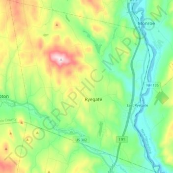
Name: Ryegate topographic map, elevation, terrain.
Location: Ryegate, Caledonia County, Vermont, 05042, United States (44.15709 -72.18756 44.27707 -72.04214)
Average elevation: 1,017 ft
Minimum elevation: 400 ft
Maximum elevation: 2,343 ft
Caledonia County trails, hiking, mountain biking, running and outdoor activities
Other topographic maps
Click on a map to view its topography, its elevation and its terrain.
East Saint Johnsbury
United States > Vermont > Caledonia County > Saint Johnsbury
Average elevation: 1,020 ft
East Burke
United States > Vermont > Caledonia County > Burke > East Burke
Average elevation: 1,066 ft