
Wanzhou topographic map
Interactive map
Click on the map to display elevation.
Wanzhou
Wanzhou spans 30°24′−31°14′ N latitude and 107°55′−108°53′ E longitude, and is situated at the eastern edge of the Sichuan Basin. It reaches a maximal north–south extent of 67.25 km (41.79 mi) and east–west width of 97.25 km (60.43 mi), covering an area of 3,214 km2 (1,241 sq mi). Elevations range from 106 m (348 ft) in the town of Tailong (太龙镇) to 1,762 m (5,781 ft) at Shaping Peak (沙坪峰) of the Qiyao Mountains (齐曜山). Bordering county-level divisions.
About this map
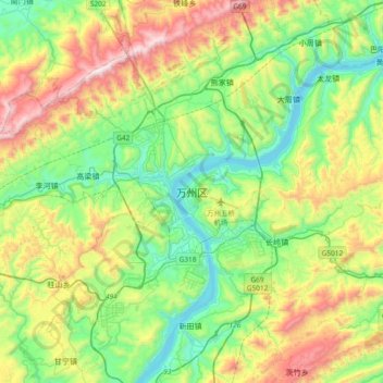
Name: Wanzhou topographic map, elevation, terrain.
Location: Wanzhou, Chongqing, 404000, China (30.65017 108.24341 30.97017 108.56341)
Average elevation: 1,654 ft
Minimum elevation: 299 ft
Maximum elevation: 4,413 ft
Other topographic maps
Click on a map to view its topography, its elevation and its terrain.
Jiangjin District
Jiangjin lies within central China at 105°49′—106°38′of longitude and 28°28′—29°28′of north latitude. The landscape and topography of Jiangjin slopes from high elevations in the south and low in the north. Luohuangzhongba stands at the lowest elevation (178.5 m). The highest site, Wugongba in…
Average elevation: 1,709 ft