
Make a donation
Gear up for your next adventure:
As an Amazon Associate, this site earns from qualifying purchases at no extra cost to you.
South Berwick topographic map
Click on the map to display elevation.
Make a donation
Gear up for your next adventure:
As an Amazon Associate, this site earns from qualifying purchases at no extra cost to you.
South Berwick
According to the United States Census Bureau, the town has a total area of 32.64 square miles (84.54 km2), of which 32.13 square miles (83.22 km2) is land and 0.51 square miles (1.32 km2) water. Located beside the New Hampshire border, South Berwick is drained by the Great Works River and Salmon Falls River. Welch Hill, elevation 370 feet (112.8 m) above sea level, is the town's highest point. The lowest elevation, which is sea level, is located along the Salmon Falls River, from the small hydroelectric dam next to the New Hampshire Route 4 bridge, south to the town's border with Eliot.
Make a donation
Gear up for your next adventure:
As an Amazon Associate, this site earns from qualifying purchases at no extra cost to you.
About this map
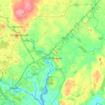
Name: South Berwick topographic map, elevation, terrain.
Location: South Berwick, York County, Maine, 03908, United States (43.17975 -70.82830 43.30243 -70.65291)
Average elevation: 151 ft
Minimum elevation: -26 ft
Maximum elevation: 417 ft
York County trails, hiking, mountain biking, running and outdoor activities
Make a donation
Gear up for your next adventure:
As an Amazon Associate, this site earns from qualifying purchases at no extra cost to you.
Other topographic maps
Click on a map to view its topography, its elevation and its terrain.
Make a donation
Gear up for your next adventure:
As an Amazon Associate, this site earns from qualifying purchases at no extra cost to you.
Make a donation
Gear up for your next adventure:
As an Amazon Associate, this site earns from qualifying purchases at no extra cost to you.