
Make a donation
Gear up for your next adventure:
As an Amazon Associate, this site earns from qualifying purchases at no extra cost to you.
Stevenage topographic map
Click on the map to display elevation.
Make a donation
Gear up for your next adventure:
As an Amazon Associate, this site earns from qualifying purchases at no extra cost to you.
About this map
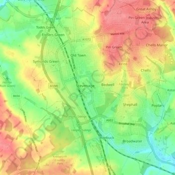
Name: Stevenage topographic map, elevation, terrain.
Location: Stevenage, Hertfordshire, England, United Kingdom (51.86932 -0.23438 51.93243 -0.14680)
Average elevation: 354 ft
Minimum elevation: 230 ft
Maximum elevation: 482 ft
Make a donation
Gear up for your next adventure:
As an Amazon Associate, this site earns from qualifying purchases at no extra cost to you.
Other topographic maps
Click on a map to view its topography, its elevation and its terrain.
Welwyn Garden City
United Kingdom > England > Hertfordshire > Welwyn Hatfield
Average elevation: 292 ft
Make a donation
Gear up for your next adventure:
As an Amazon Associate, this site earns from qualifying purchases at no extra cost to you.
Make a donation
Gear up for your next adventure:
As an Amazon Associate, this site earns from qualifying purchases at no extra cost to you.
Bushey Heath
United Kingdom > England > Hertfordshire > Hertsmere > Bushey Heath
Average elevation: 361 ft
Bishops Stortford Elsan Point
United Kingdom > England > Hertfordshire > East Hertfordshire
Average elevation: 256 ft