
Post Falls topographic map
Interactive map
Click on the map to display elevation.
Post Falls
Post Falls features a varied and distinctive topography characterized by its placement on the Rathdrum Prairie, which lies at an elevation of approximately 2,182 feet (665 meters) above sea level. This prairie is surrounded by rolling hills and rugged terrain that gradually rise towards the nearby Rocky Mountains to the east. The Spokane River runs through the city, creating dramatic waterfalls that enhance the area's natural beauty and provide a vibrant ecosystem. The landscape transitions from flat agricultural land in the prairie to more rugged and wooded areas as one moves towards the mountains, making it a region rich in both scenic vistas and recreational opportunities.
About this map
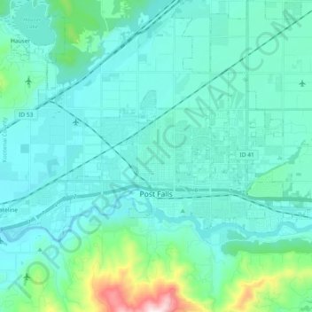
Name: Post Falls topographic map, elevation, terrain.
Location: Post Falls, Kootenai County, Idaho, 83854, United States (47.69255 -117.04170 47.75945 -116.85641)
Average elevation: 2,329 ft
Minimum elevation: 2,031 ft
Maximum elevation: 4,249 ft
Kootenai County trails, hiking, mountain biking, running and outdoor activities
Other topographic maps
Click on a map to view its topography, its elevation and its terrain.
Bayview
United States > Idaho > Kootenai County
Bayview is an unincorporated community in the northwest United States, located in Kootenai County, Idaho, north of Coeur d'Alene. On the southwest shore of Lake Pend Oreille, Bayview is seven miles (11 km) east-northeast of Athol. The community is served by State Highway 54 and a post office with ZIP code…
Average elevation: 2,405 ft