
Joe Pool Lake topographic map
Interactive map
Click on the map to display elevation.
About this map
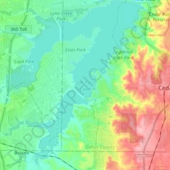
Name: Joe Pool Lake topographic map, elevation, terrain.
Average elevation: 610 ft
Minimum elevation: 492 ft
Maximum elevation: 879 ft
Other topographic maps
Click on a map to view its topography, its elevation and its terrain.
Westchester Valley
United States > Texas > Dallas County > Grand Prairie
Westchester Valley, Grand Prairie, Dallas County, Texas, 75054, United States
Average elevation: 518 ft
South Westchester Meadows
United States > Texas > Dallas County > Grand Prairie
South Westchester Meadows, Grand Prairie, Dallas County, Texas, 75052, United States
Average elevation: 512 ft
Shady Grove
United States > Texas > Dallas County > Grand Prairie
Shady Grove, Grand Prairie, Dallas County, Texas, 75050, United States
Average elevation: 479 ft
South Westchester Meadow
United States > Texas > Dallas County > Grand Prairie
South Westchester Meadow, Grand Prairie, Dallas County, Texas, 75052, United States
Average elevation: 518 ft
Lakeview
United States > Texas > Dallas County > Grand Prairie
Lakeview, Grand Prairie, Dallas County, Texas, 75051, United States
Average elevation: 489 ft
Grand Prairie
United States > Texas > Dallas County > Grand Prairie
Grand Prairie, Dallas County, Texas, 75051, United States
Average elevation: 558 ft