
Grand Prairie topographic map
Click on the map to display elevation.
About this map
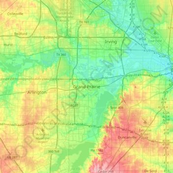
Name: Grand Prairie topographic map, elevation, terrain.
Location: Grand Prairie, Dallas County, Texas, 75051, United States (32.58596 -97.15778 32.90596 -96.83778)
Average elevation: 558 ft
Minimum elevation: 394 ft
Maximum elevation: 860 ft
Dallas County trails, hiking, mountain biking, running and outdoor activities
Other topographic maps
Click on a map to view its topography, its elevation and its terrain.