Geolocate

Joe Pool Lake topographic map

Click on the map to display elevation.

About this map

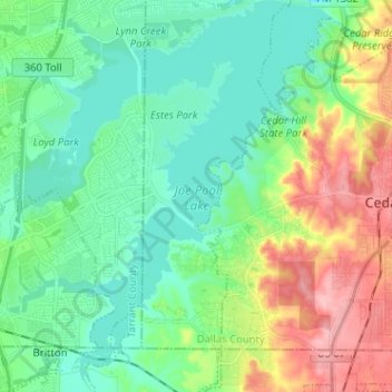
Name: Joe Pool Lake topographic map, elevation, terrain.

Location: Joe Pool Lake, Grand Prairie, Dallas County, Texas, 75054, United States (32.53659 -97.06698 32.64417 -96.97672)

Average elevation: 610 ft

Minimum elevation: 492 ft

Maximum elevation: 879 ft

Dallas County trails, hiking, mountain biking, running and outdoor activities

Other topographic maps

Click on a map to view its topography, its elevation and its terrain.

Grand Prairie

United States > Texas > Dallas County > Grand Prairie

Average elevation: 558 ft

Lakeview

United States > Texas > Dallas County > Grand Prairie

Average elevation: 489 ft

Shady Grove

United States > Texas > Dallas County > Grand Prairie

Average elevation: 479 ft

Gear up for your next adventure:

🧯Portable Fire Pit - Compact fire pit for camping spots
📚USA Hiking Guide Books - Top trail guides and map books
🔭Stargazing Telescopes - Perfect for camping in low-light pollution areas shown on maps
🎒Outdoor Daypacks - Lightweight backpacks designed for carrying maps and essential gear
🚪Portable Camp Chair - Foldable chair for comfort at camp

As an Amazon Associate, this site earns from qualifying purchases at no extra cost to you.