
Make a donation
Gear up for your next adventure:
As an Amazon Associate, this site earns from qualifying purchases at no extra cost to you.
Woodland Township topographic map
Click on the map to display elevation.
Make a donation
Gear up for your next adventure:
As an Amazon Associate, this site earns from qualifying purchases at no extra cost to you.
About this map
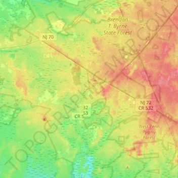
Name: Woodland Township topographic map, elevation, terrain.
Average elevation: 112 ft
Minimum elevation: 23 ft
Maximum elevation: 207 ft
Burlington County trails, hiking, mountain biking, running and outdoor activities
Make a donation
Gear up for your next adventure:
As an Amazon Associate, this site earns from qualifying purchases at no extra cost to you.
Other topographic maps
Click on a map to view its topography, its elevation and its terrain.
Indian Mills
United States > New Jersey > Burlington County > Shamong Township
Average elevation: 82 ft
Make a donation
Gear up for your next adventure:
As an Amazon Associate, this site earns from qualifying purchases at no extra cost to you.
Coxs Corner
United States > New Jersey > Burlington County > Mount Laurel Township
Average elevation: 69 ft
Make a donation
Gear up for your next adventure:
As an Amazon Associate, this site earns from qualifying purchases at no extra cost to you.
Franklin Park
United States > New Jersey > Burlington County > Willingboro Township
Average elevation: 36 ft
Freedom Park
United States > New Jersey > Burlington County > Medford Township
Average elevation: 52 ft
Make a donation
Gear up for your next adventure:
As an Amazon Associate, this site earns from qualifying purchases at no extra cost to you.
Colemantown
United States > New Jersey > Burlington County > Mount Laurel Township
Average elevation: 66 ft
Make a donation
Gear up for your next adventure:
As an Amazon Associate, this site earns from qualifying purchases at no extra cost to you.
Make a donation
Gear up for your next adventure:
As an Amazon Associate, this site earns from qualifying purchases at no extra cost to you.
Burlington
United States > New Jersey > Burlington County > Burlington City > Burlington
Average elevation: 36 ft
Make a donation
Gear up for your next adventure:
As an Amazon Associate, this site earns from qualifying purchases at no extra cost to you.
Chambers Corners
United States > New Jersey > Burlington County > Chambers Corners
Average elevation: 62 ft
Make a donation
Gear up for your next adventure:
As an Amazon Associate, this site earns from qualifying purchases at no extra cost to you.
Garfield Park East
United States > New Jersey > Burlington County > Willingboro > Garfield Park East
Average elevation: 52 ft
Apple Pie Hill Station Fire Tower
United States > New Jersey > Burlington County > Tabernacle Township
Average elevation: 112 ft
Make a donation
Gear up for your next adventure:
As an Amazon Associate, this site earns from qualifying purchases at no extra cost to you.
Fellowship
United States > New Jersey > Burlington County > Mount Laurel Township
Average elevation: 52 ft