
Make a donation
Gear up for your next adventure:
As an Amazon Associate, this site earns from qualifying purchases at no extra cost to you.
Southampton Township topographic map
Click on the map to display elevation.
Make a donation
Gear up for your next adventure:
As an Amazon Associate, this site earns from qualifying purchases at no extra cost to you.
About this map
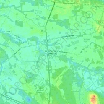
Name: Southampton Township topographic map, elevation, terrain.
Average elevation: 49 ft
Minimum elevation: 16 ft
Maximum elevation: 135 ft
Burlington County trails, hiking, mountain biking, running and outdoor activities
Make a donation
Gear up for your next adventure:
As an Amazon Associate, this site earns from qualifying purchases at no extra cost to you.
Other topographic maps
Click on a map to view its topography, its elevation and its terrain.
Westampton, New Jersey
United States > New Jersey > Burlington County > Westampton, New Jersey
Average elevation: 52 ft
Make a donation
Gear up for your next adventure:
As an Amazon Associate, this site earns from qualifying purchases at no extra cost to you.
Penn State Forest
United States > New Jersey > Burlington County
In 1912, the state ran a 9 mi (14 km) telephone line across what was initially called Penn Reserve. A wooden fire lookout tower was constructed on Bear Swamp Hill (elevation 165 ft (50 m)) in 1915. After the wooden tower burnt down, a modern fire lookout tower was built in 1960. That tower was destroyed when a…
Average elevation: 89 ft
Make a donation
Gear up for your next adventure:
As an Amazon Associate, this site earns from qualifying purchases at no extra cost to you.
Freedom Park
United States > New Jersey > Burlington County > Medford Township
Average elevation: 52 ft
Pemberton Heights
United States > New Jersey > Burlington County > Pemberton Heights
Average elevation: 62 ft
Make a donation
Gear up for your next adventure:
As an Amazon Associate, this site earns from qualifying purchases at no extra cost to you.
Medford Lakes
United States > New Jersey > Burlington County
On July 12, 2004, the borough suffered substantial damage due to flooding, caused by 7.26 inches of rainfall over 14 hours. This led to the breaking of several dams, including the Quogue Dam and the Lower and Upper Aetna Lake Dams, causing water levels to rise beyond 500-year flood elevations on portions of…
Average elevation: 89 ft
Make a donation
Gear up for your next adventure:
As an Amazon Associate, this site earns from qualifying purchases at no extra cost to you.