
Stokes State Forest topographic map
Interactive map
Click on the map to display elevation.
Stokes State Forest
The pavilion at the top of the peak makes a great place to picnic. To make traveling to Sunrise more interesting, one can look for the New Jersey shaped rock. The mountain is the second highest point in New Jersey, being 1,653 feet (504 m) above sea level. Hikers are amazed with the view. There is a USGS marker at the top of the mountain which gives the elevation. To get there, the hiking stretch is a quarter of a mile from a parking lot. Much of Sussex County can be seen from the summit of the mountain. From the eastern side of the mountain, one can view the Kittatinny Valley and the Highlands. From the western side, the Delaware Valley and the Port Jervis trough can be seen. From the top of Sunrise Mountain you can see three states, New Jersey, New York, and Pennsylvania.
About this map
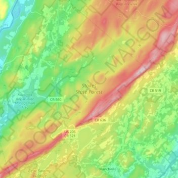
Name: Stokes State Forest topographic map, elevation, terrain.
Average elevation: 853 ft
Minimum elevation: 344 ft
Maximum elevation: 1,591 ft
Sussex County trails, hiking, mountain biking, running and outdoor activities
Other topographic maps
Click on a map to view its topography, its elevation and its terrain.
Sparta
United States > New Jersey > Sussex County > Sparta Township > Sparta
Average elevation: 906 ft
Lake Neepaulin
United States > New Jersey > Sussex County > Wantage
Lake Neepaulin is a man-made lake created from the damming of Neepaulakating Creek, a small mountain stream that was not named until 2002. The creek's headwaters are located approximately 0.4 miles (0.64 km) northwest of the north end of Lake Neepaulin. These headwaters are located a short distance south of…
Average elevation: 564 ft
High Point
United States > New Jersey > Sussex County > Montague Township
High Point is a mountain peak within High Point State Park on the border of Wantage Township and Montague Township, Sussex County, New Jersey. Located in the portion of the state known as the Skylands, it is the highest elevation in the state, with a peak elevation of 1,803 feet (550 m). The closest city is…
Average elevation: 1,362 ft
Montague Township
United States > New Jersey > Sussex County > Montague Township
Montague Township is a township in Sussex County, in the U.S. state of New Jersey, in the New York City Metropolitan Area. As of the 2020 United States census, the township's population was 3,792, a decrease of 55 (−1.4%) from the 2010 census count of 3,847, which in turn reflected an increase of 435…
Average elevation: 584 ft
Swartswood
United States > New Jersey > Sussex County > Stillwater Township > Swartswood
Average elevation: 643 ft
Lafayette
United States > New Jersey > Sussex County > Lafayette Township > Lafayette
Average elevation: 594 ft
Sunrise Moutain Overlook
United States > New Jersey > Sussex County > Frankford Township
Average elevation: 1,129 ft
Independence Corner
United States > New Jersey > Sussex County > Vernon Township
Average elevation: 633 ft