
Elizabethtown topographic map
Interactive map
Click on the map to display elevation.
About this map
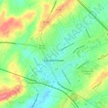
Name: Elizabethtown topographic map, elevation, terrain.
Average elevation: 502 ft
Minimum elevation: 404 ft
Maximum elevation: 643 ft
Lancaster County trails, hiking, mountain biking, running and outdoor activities
Other topographic maps
Click on a map to view its topography, its elevation and its terrain.
Smithville
United States > Pennsylvania > Lancaster County > Providence Township
Average elevation: 459 ft
Reinholds
United States > Pennsylvania > Lancaster County > West Cocalico Township
Average elevation: 522 ft
Stevens
United States > Pennsylvania > Lancaster County > West Cocalico Township
Average elevation: 397 ft
Coopersville
United States > Pennsylvania > Lancaster County > Sadsbury Township
Average elevation: 600 ft
Baumgardner
United States > Pennsylvania > Lancaster County > Pequea Township
Average elevation: 413 ft
Locust Grove
United States > Pennsylvania > Lancaster County > Conoy Township
Average elevation: 315 ft
Welsh Mountain
United States > Pennsylvania > Lancaster County > Caernarvon Township
Average elevation: 764 ft
Safe Harbor
United States > Pennsylvania > Lancaster County > Conestoga Township
Average elevation: 338 ft
Churchtown
United States > Pennsylvania > Lancaster County > Caernarvon Township
Average elevation: 535 ft
Brooklawn
United States > Pennsylvania > Lancaster County > Manheim Township > Neffsville
Average elevation: 381 ft
Bowling Green
United States > Pennsylvania > Lancaster County > Manor Township
Average elevation: 351 ft
Reinholds
United States > Pennsylvania > Lancaster County > West Cocalico Township
Average elevation: 522 ft
Stevens
United States > Pennsylvania > Lancaster County > West Cocalico Township
Average elevation: 397 ft
Chestnut Ridge
United States > Pennsylvania > Lancaster County > Rohrerstown > Chestnut Ridge
Average elevation: 400 ft
Brownstown
United States > Pennsylvania > Lancaster County > West Earl Township
Average elevation: 335 ft
Landisville
United States > Pennsylvania > Lancaster County > East Hempfield Township
Average elevation: 400 ft