
Holden topographic map
Interactive map
Click on the map to display elevation.
About this map
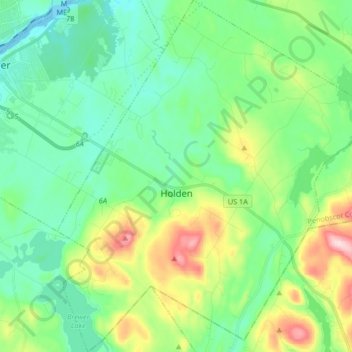
Name: Holden topographic map, elevation, terrain.
Location: Holden, Penobscot County, Maine, 04429, United States (44.69968 -68.73514 44.81735 -68.59094)
Average elevation: 243 ft
Minimum elevation: -13 ft
Maximum elevation: 883 ft
Penobscot County trails, hiking, mountain biking, running and outdoor activities
Other topographic maps
Click on a map to view its topography, its elevation and its terrain.