Geolocate

Denmark topographic map

Interactive map

Click on the map to display elevation.

About this map

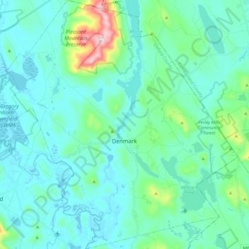
Name: Denmark topographic map, elevation, terrain.

Location: Denmark, Oxford County, Maine, 04022, United States (43.91024 -70.89519 44.04953 -70.71541)

Average elevation: 571 ft

Minimum elevation: 335 ft

Maximum elevation: 1,965 ft

Oxford County trails, hiking, mountain biking, running and outdoor activities

Other topographic maps

Click on a map to view its topography, its elevation and its terrain.

Bryant Pond

United States > Maine > Oxford County > Woodstock

Average elevation: 886 ft

Boston Hills

United States > Maine > Oxford County > Denmark

Average elevation: 446 ft

Sunday River

United States > Maine > Oxford County > Bethel

Average elevation: 915 ft

Old Speck Mountain

United States > Maine > Oxford County

Average elevation: 3,094 ft

Record Hill

United States > Maine > Oxford County > Byron

Average elevation: 1,565 ft

West Bethel

United States > Maine > Oxford County > Bethel

Average elevation: 827 ft

Grover Hill

United States > Maine > Oxford County

Average elevation: 817 ft

Sugarloaf

United States > Maine > Oxford County > Dixfield

Average elevation: 778 ft