
Make a donation
Gear up for your next adventure:
As an Amazon Associate, this site earns from qualifying purchases at no extra cost to you.
Grover Hill topographic map
Click on the map to display elevation.
Make a donation
Gear up for your next adventure:
As an Amazon Associate, this site earns from qualifying purchases at no extra cost to you.
About this map
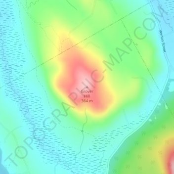
Name: Grover Hill topographic map, elevation, terrain.
Location: Grover Hill, Oxford County, Maine, 04217, United States (44.37168 -70.77012 44.37178 -70.77002)
Average elevation: 817 ft
Minimum elevation: 650 ft
Maximum elevation: 1,211 ft
Oxford County trails, hiking, mountain biking, running and outdoor activities
Make a donation
Gear up for your next adventure:
As an Amazon Associate, this site earns from qualifying purchases at no extra cost to you.
Other topographic maps
Click on a map to view its topography, its elevation and its terrain.
Make a donation
Gear up for your next adventure:
As an Amazon Associate, this site earns from qualifying purchases at no extra cost to you.
Make a donation
Gear up for your next adventure:
As an Amazon Associate, this site earns from qualifying purchases at no extra cost to you.
Paris
United States > Maine > Oxford County
It was first settled near the center of the town in 1779 by Lemuel Jackson, John Willis and their families. Organized as Number Four Plantation, it was incorporated as Paris on June 20, 1793. At the establishment of Oxford County in 1805, Paris was designated its county seat and developed into a thriving…
Average elevation: 679 ft
Make a donation
Gear up for your next adventure:
As an Amazon Associate, this site earns from qualifying purchases at no extra cost to you.
Make a donation
Gear up for your next adventure:
As an Amazon Associate, this site earns from qualifying purchases at no extra cost to you.
Mooselookmeguntic Lake
United States > Maine > Oxford County > Adamstown Township
Average elevation: 1,667 ft