
Windham County topographic map
Interactive map
Click on the map to display elevation.
About this map
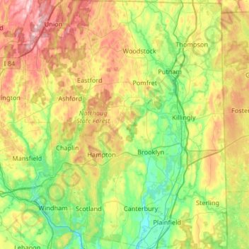
Name: Windham County topographic map, elevation, terrain.
Average elevation: 512 ft
Minimum elevation: 92 ft
Maximum elevation: 1,306 ft
Other topographic maps
Click on a map to view its topography, its elevation and its terrain.
East Putnam
United States > Connecticut > Northeastern Connecticut Planning Region > Putnam
Average elevation: 486 ft
Pomfret Center
United States > Connecticut > Northeastern Connecticut Planning Region > Pomfret
Average elevation: 495 ft
Beachdale
United States > Connecticut > Northeastern Connecticut Planning Region > Voluntown
Average elevation: 308 ft
Rogers
United States > Connecticut > Northeastern Connecticut Planning Region > Killingly
Average elevation: 272 ft
West Thompson
United States > Connecticut > Northeastern Connecticut Planning Region > Thompson
Average elevation: 377 ft
Plainfield Village
United States > Connecticut > Northeastern Connecticut Planning Region > Plainfield
Average elevation: 203 ft
Wauregan
United States > Connecticut > Northeastern Connecticut Planning Region > Plainfield
The village is centered on the former site of the mill on the east bank of the Quinebaug River, near where modern Route 205 crosses the river. The village extends eastward from the river up a gently rising slope towards Route 12 located at the crest of a ridge. The mill workers' houses are located along Walnut…
Average elevation: 223 ft
Moosup
United States > Connecticut > Northeastern Connecticut Planning Region > Plainfield
Average elevation: 312 ft
Westminster
United States > Connecticut > Northeastern Connecticut Planning Region > Canterbury
Average elevation: 427 ft
West Woodstock
United States > Connecticut > Northeastern Connecticut Planning Region > Woodstock
Average elevation: 751 ft