
Edison topographic map
Interactive map
Click on the map to display elevation.
Edison
While the Township's topography is mostly flat, there are some hillier areas, especially along the Perth Amboy Moraine, which forms an arc across the township, left by the southern limit of the Laurentide Ice Sheet. The highest point is on Grandview Avenue, which reaches a maximum elevation of about 220 feet. The lowest elevation in the township is on sea level on the Raritan River.
About this map
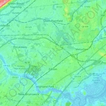
Name: Edison topographic map, elevation, terrain.
Location: Edison, Middlesex County, New Jersey, United States (40.47136 -74.44032 40.60550 -74.31605)
Average elevation: 82 ft
Minimum elevation: -7 ft
Maximum elevation: 509 ft
Middlesex County trails, hiking, mountain biking, running and outdoor activities
Other topographic maps
Click on a map to view its topography, its elevation and its terrain.
Elmer B Boyd Park
United States > New Jersey > Middlesex County > New Brunswick > Feaster Park
Average elevation: 72 ft
Fieldville
United States > New Jersey > Middlesex County > Piscataway Township
Average elevation: 56 ft
Sand Hills
United States > New Jersey > Middlesex County > Woodbridge Township > Fords
Average elevation: 79 ft
Middlesex Downs
United States > New Jersey > Middlesex County > Monroe Township
Average elevation: 108 ft
Woodbridge
United States > New Jersey > Middlesex County > Woodbridge Township
Average elevation: 52 ft
Prospect Plains
United States > New Jersey > Middlesex County > Monroe Township
Average elevation: 128 ft
Berdines Corners
United States > New Jersey > Middlesex County > North Brunswick
Average elevation: 95 ft
Lynn Woodoaks
United States > New Jersey > Middlesex County > Woodbridge Township > Colonia
Average elevation: 102 ft
Fairview Knolls
United States > New Jersey > Middlesex County > East Brunswick Township
Average elevation: 102 ft
South River
United States > New Jersey > Middlesex County > South River > South River
Average elevation: 62 ft
Ten Mile Run
United States > New Jersey > Middlesex County > South Brunswick
Average elevation: 217 ft
Highland Park
United States > New Jersey > Middlesex County > Highland Park > Highland Park
Average elevation: 79 ft
New Market
United States > New Jersey > Middlesex County > Piscataway Township
Average elevation: 75 ft