
Pinellas Park topographic map
Interactive map
Click on the map to display elevation.
Pinellas Park
Pinellas Park, located in Pinellas County, Florida, features relatively flat terrain characteristic of the broader region. Situated on the Pinellas Peninsula, the city is part of an area that is only a few feet above sea level. The landscape includes low-lying wetlands, coastal marshes, and several small freshwater bodies, with the land primarily shaped by ancient shorelines and tidal flats. The terrain is gently sloped toward the Gulf of Mexico, and the area has a mix of urbanized land and preserved natural spaces. Additionally, due to its proximity to the Gulf Coast, the region experiences coastal erosion and occasional flooding, which further defines its topography.
About this map
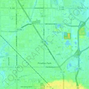
Name: Pinellas Park topographic map, elevation, terrain.
Location: Pinellas Park, Pinellas County, Florida, United States (27.82458 -82.75727 27.89546 -82.66389)
Average elevation: 23 ft
Minimum elevation: -10 ft
Maximum elevation: 66 ft
Pinellas County trails, hiking, mountain biking, running and outdoor activities
Other topographic maps
Click on a map to view its topography, its elevation and its terrain.
Palm Harbor
United States > Florida > Pinellas County
Palm Harbor is characterized by its unique topography, which features a relatively rare hilly landscape for the region. Unlike much of the surrounding areas in Pinellas County, which are predominantly flat, Palm Harbor includes elevations that can reach up to about 75 feet above sea level. This elevation gives…
Average elevation: 30 ft
Fort De Soto County Park
United States > Florida > Pinellas County > Saint Petersburg
Average elevation: 0 ft
Boyd Hill Nature Preserve
United States > Florida > Pinellas County > Saint Petersburg > Lakewood Estates
Average elevation: 23 ft
Boyd Hill Nature Preserve
United States > Florida > Pinellas County > Saint Petersburg > Lakewood Estates
Average elevation: 23 ft
Splash Harbour Water Park
United States > Florida > Pinellas County > Indian Rocks Beach
Average elevation: 13 ft
Lealman
United States > Florida > Pinellas County
Lealman is located at 27°49′10″N 82°41′4″W / 27.81944°N 82.68444°W / 27.81944; -82.68444 (27.8197, -82.6846). The community is bordered by the city of Pinellas Park to the north, St. Petersburg to the east and south, and by the town of West Lealman to the west. The elevation is 49 feet (15…
Average elevation: 43 ft
Middle Tampa Bay
United States > Florida > Pinellas County > Saint Petersburg
Average elevation: 13 ft
Frenchman's Creek
United States > Florida > Pinellas County > Saint Petersburg
Average elevation: 13 ft
Lakewood Estates
United States > Florida > Pinellas County > Saint Petersburg
Average elevation: 23 ft
Acklocknayke (historical)
United States > Florida > Pinellas County > Palm Harbor
Average elevation: 10 ft
Honeymoon Island Dog Beach
United States > Florida > Pinellas County > Palm Harbor
Average elevation: 0 ft
Saint Petersburg
United States > Florida > Pinellas County > Saint Petersburg
Average elevation: 10 ft