
Livermore topographic map
Interactive map
Click on the map to display elevation.
About this map
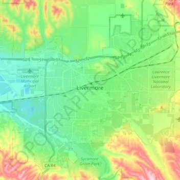
Name: Livermore topographic map, elevation, terrain.
Location: Livermore, Alameda County, California, United States (37.62857 -121.84810 37.73223 -121.69664)
Average elevation: 604 ft
Minimum elevation: 285 ft
Maximum elevation: 1,322 ft
Alameda County trails, hiking, mountain biking, running and outdoor activities
Other topographic maps
Click on a map to view its topography, its elevation and its terrain.
Berkeley Hills
United States > California > Alameda County > Berkeley
The Berkeley Hills are bounded by the major Hayward Fault along their western base, and the minor Wildcat fault on their eastern side. The highest peaks are Grizzly Peak with an elevation of 1,754 feet (535 m) and Round Top, an extinct volcano with an elevation of 1,761 feet (537 m) and William Rust Summit at…
Average elevation: 518 ft
Contra Costa Rock Park
United States > California > Alameda County > Berkeley
Average elevation: 371 ft
Coyote Hills Regional Park
United States > California > Alameda County > Fremont
Average elevation: 16 ft