
Make a donation
Gear up for your next adventure:
As an Amazon Associate, this site earns from qualifying purchases at no extra cost to you.
Mantes-la-Jolie topographic map
Click on the map to display elevation.
Make a donation
Gear up for your next adventure:
As an Amazon Associate, this site earns from qualifying purchases at no extra cost to you.
About this map
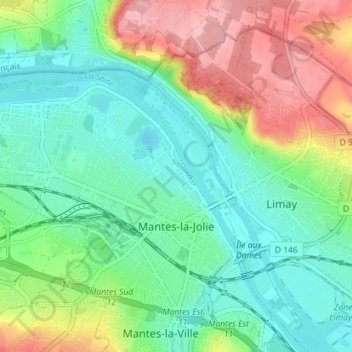
Name: Mantes-la-Jolie topographic map, elevation, terrain.
Average elevation: 184 ft
Minimum elevation: 39 ft
Maximum elevation: 459 ft
Make a donation
Gear up for your next adventure:
As an Amazon Associate, this site earns from qualifying purchases at no extra cost to you.
Other topographic maps
Click on a map to view its topography, its elevation and its terrain.
Le Champtier des Fourneaux
France > Ile-de-France > Yvelines > Dampierre-en-Yvelines
Average elevation: 469 ft
Make a donation
Gear up for your next adventure:
As an Amazon Associate, this site earns from qualifying purchases at no extra cost to you.
Val des Quatre Pignons
France > Ile-de-France > Yvelines > Beynes > Val des Quatre Pignons
Average elevation: 302 ft
Make a donation
Gear up for your next adventure:
As an Amazon Associate, this site earns from qualifying purchases at no extra cost to you.