
Make a donation
Gear up for your next adventure:
As an Amazon Associate, this site earns from qualifying purchases at no extra cost to you.
Conroe topographic map
Click on the map to display elevation.
Make a donation
Gear up for your next adventure:
As an Amazon Associate, this site earns from qualifying purchases at no extra cost to you.
Conroe
Conroe features a predominantly flat terrain with an average elevation of approximately 220 feet (67 meters) above sea level. The area is characterized by gently rolling hills interspersed with numerous lakes and wetlands, including the prominent Lake Conroe, which spans about 21,000 acres. The lake, formed by the Conroe Dam, contributes to the local ecosystem and recreational opportunities, providing a habitat for diverse wildlife. Surrounding the city, you'll find lush forests, notably the Sam Houston National Forest to the east, which adds to the scenic beauty and biodiversity of the region. This combination of water bodies and wooded areas creates a picturesque landscape, making Conroe an attractive place for both residents and visitors.
Make a donation
Gear up for your next adventure:
As an Amazon Associate, this site earns from qualifying purchases at no extra cost to you.
About this map
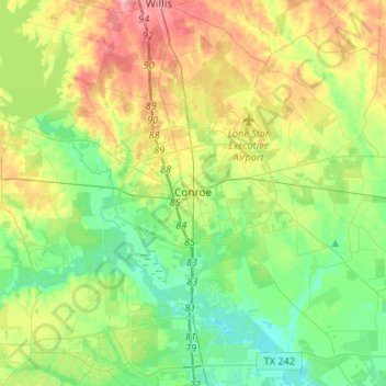
Name: Conroe topographic map, elevation, terrain.
Location: Conroe, Montgomery County, Texas, United States (30.20266 -95.65670 30.41999 -95.39094)
Average elevation: 203 ft
Minimum elevation: 89 ft
Maximum elevation: 404 ft
Montgomery County trails, hiking, mountain biking, running and outdoor activities
Make a donation
Gear up for your next adventure:
As an Amazon Associate, this site earns from qualifying purchases at no extra cost to you.
Other topographic maps
Click on a map to view its topography, its elevation and its terrain.
Make a donation
Gear up for your next adventure:
As an Amazon Associate, this site earns from qualifying purchases at no extra cost to you.
Make a donation
Gear up for your next adventure:
As an Amazon Associate, this site earns from qualifying purchases at no extra cost to you.
Make a donation
Gear up for your next adventure:
As an Amazon Associate, this site earns from qualifying purchases at no extra cost to you.
Make a donation
Gear up for your next adventure:
As an Amazon Associate, this site earns from qualifying purchases at no extra cost to you.