
Sulawesi topographic map
Interactive map
Click on the map to display elevation.
Sulawesi
The lowland forests on the island have mostly been removed. Because of the relative geological youth of the island and its dramatic and sharp topography, the lowland areas are naturally limited in their extent. The past decade has seen dramatic conversion of this rare and endangered habitat. The island also possesses one of the largest outcrops of serpentine soil in the world, which support an unusual and large community of specialized plant species. Overall, the flora and fauna of this unique center of global biodiversity is very poorly documented and understood and remains critically threatened.
About this map
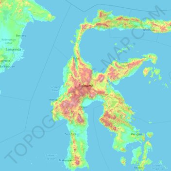
Name: Sulawesi topographic map, elevation, terrain.
Location: Sulawesi, Indonesia (-5.70288 118.75714 1.75131 125.24781)
Average elevation: 476 ft
Minimum elevation: -10 ft
Maximum elevation: 11,171 ft
Other topographic maps
Click on a map to view its topography, its elevation and its terrain.
Ngamprah
Indonesia > West Java > West Bandung
Ngamprah has an elevation moderated tropical rainforest climate (Af) with moderate rainfall from June to September and heavy rainfall from October to May.
Average elevation: 2,635 ft
Ngamprah
Indonesia > West Java > West Bandung
Ngamprah has an elevation moderated tropical rainforest climate (Af) with moderate rainfall from June to September and heavy rainfall from October to May.
Average elevation: 2,635 ft
Karangmalang
Indonesia > Special Region of Yogyakarta > Sleman Regency > Catur tunggal
Average elevation: 456 ft