Geolocate

Borneo topographic map

Click on the map to display elevation.

Borneo

Before sea levels rose at the end of the last ice age, Borneo was part of the mainland of Asia, forming, with Java and Sumatra, the upland regions of a peninsula that extended east from present day Indochina. The South China Sea and Gulf of Thailand now submerge the former low-lying areas of the peninsula. Deeper waters separating Borneo from neighbouring Sulawesi prevented a land connection to that island, creating the divide known as Wallace's Line between Asian and Australia-New Guinea biological regions. The island today is surrounded by the South China Sea to the north and northwest, the Sulu Sea to the northeast, the Celebes Sea and the Makassar Strait to the east, and the Java Sea and Karimata Strait to the south. To the west of Borneo are the Malay Peninsula and Sumatra. To the south and east are islands of Indonesia: Java and Sulawesi, respectively. To the northeast are the Philippine Islands. With an area of 743,330 square kilometres (287,000 sq mi), it is the third-largest island in the world, and is the largest island of Asia (the largest continent). Its highest point is Mount Kinabalu in Sabah, Malaysia, with an elevation of 4,095 m (13,435 ft).

Wikipedia (CC-BY-SA 3.0)

About this map

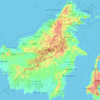
Name: Borneo topographic map, elevation, terrain.

Location: Borneo, Kalimantan, Indonesia (-4.17791 108.83747 7.03748 119.26689)

Average elevation: 463 ft

Minimum elevation: -13 ft

Maximum elevation: 12,493 ft

Other topographic maps

Click on a map to view its topography, its elevation and its terrain.

Bantarsoka

Indonesia > Central Java > Banyumas

Average elevation: 253 ft

Bali

Indonesia > Bali

Average elevation: 157 ft

Tlogosari Kulon

Indonesia > Central Java > Semarang

Average elevation: 23 ft

Gayamprit

Indonesia > Central Java > Klaten

Average elevation: 558 ft

Essang

Indonesia > North Sulawesi

Average elevation: 59 ft

Cenggerengan

Indonesia > East Java > Ngawi

Average elevation: 259 ft

Krakatoa

Indonesia > Lampung > Lampung Selatan

Average elevation: 66 ft

Payangan

Indonesia > Bali > Gianyar

Average elevation: 1,391 ft

Lumut

Indonesia > Aceh > Aceh Tengah

Average elevation: 1,841 ft

Bantarsoka

Indonesia > Central Java > Banyumas

Average elevation: 253 ft

Gersik

Indonesia > East Kalimantan > Penajam Paser Utara

Average elevation: 26 ft

Lubangbuaya

Indonesia > West Java

Average elevation: 121 ft

Aluebutuha

Indonesia > Aceh > Aceh Timur

Average elevation: 43 ft

Surabaya

Indonesia > East Java

Average elevation: 36 ft

Bandung

Indonesia > West Java

Bandung (Sundanese: ᮘᮔ᮪ᮓᮥᮀ, romanized: Bandung, Sundanese pronunciation: [ˈbandʊŋ]; /ˈbɑːndʊŋ/) is the capital city of the Indonesian province of West Java. It has a population of 2,452,943 within its city limits according to the official estimates as at mid 2021, making it the fourth most…

Average elevation: 2,930 ft

Timika

Indonesia > Central Papua > Mimika

Average elevation: 75 ft

Uluwatu

Indonesia > Bali > Badung

Average elevation: 102 ft

Nuanu Creative City

Indonesia > Bali > Tabanan > Beraban

Average elevation: 46 ft

Taman Gesit

Indonesia > West Java > Bandung City > Lebak Gede

Average elevation: 2,448 ft

Cileunyi Wetan

Indonesia > West Java > Kabupaten Bandung > Cileunyi

Average elevation: 2,349 ft

Essang

Indonesia > Sumenep

Average elevation: 92 ft

Situ II ITB

Indonesia > West Java > Sumedang > Jatinangor

Average elevation: 2,382 ft

Gunung Beratus

Indonesia > East Kalimantan

Average elevation: 2,126 ft

Paniki Atas

Indonesia > North Sulawesi > Minahasa Utara

Average elevation: 299 ft

Tembagapura

Indonesia > Central Papua > Mimika

Tembagapura is situated on a rocky plain at an altitude of 1,930 metres (6,330 ft) at the base of Mount Zaagkam, which lies 16 kilometres (9.9 mi) southeast of the mine. The town is in the Sudirman Range, not far from Puncak Jaya (Mount Carstens), the highest peak in Oceania. The area gets about 3,220…

Average elevation: 8,163 ft

Gunung Andong

Indonesia > East Java > Jember

Average elevation: 2,562 ft

Babelan

Indonesia > West Java

Average elevation: 16 ft

Hanua

Indonesia > Central Kalimantan > Pulang Pisau

Average elevation: 52 ft

Tanah Grogot

Indonesia > East Kalimantan > Paser

Average elevation: 16 ft

Kenangkan

Indonesia > Central Java > Kabupaten Semarang > Bergas

Average elevation: 1,617 ft

Jungkat

Indonesia > West Kalimantan > Mempawah

Average elevation: 3 ft

Cilengkrang

Indonesia > Kabupaten Bandung

Average elevation: 2,638 ft

Blok D

Indonesia > West Java > Kabupaten Bandung > Cilengkrang

Average elevation: 2,621 ft

Cipanjalu

Indonesia > West Java > Kabupaten Bandung

Average elevation: 3,199 ft

Sangatta

Indonesia > East Kalimantan > Kutai Timur

Average elevation: 26 ft

Gunung Rumput

Indonesia > West Kalimantan > Sambas

Average elevation: 4,062 ft

Jimbaran

Indonesia > Bali > Badung > Jimbaran

Average elevation: 30 ft

Rinjani

Indonesia > West Nusa Tenggara

In September 1995 an aviation report was issued concerning an unconfirmed ash cloud from Rinjani. A NOTAM about volcanic activity from Rinjani was issued by the Bali Flight Information Region on the morning of 12 September. An ash cloud was reportedly drifting to the south west with the cloud top around 4 km…

Average elevation: 10,075 ft

Muarasoma

Indonesia > North Sumatra > Mandailing Natal

Average elevation: 850 ft

Wangen

Indonesia > Central Java > Klaten

Average elevation: 689 ft

Gunung Hauk

Indonesia > South Kalimantan > Balangan

Average elevation: 2,119 ft

Langowan

Indonesia > North Sulawesi

Average elevation: 2,428 ft

Tegal

Indonesia > West Java > Bogor > Tenjo > Cilaku

Average elevation: 177 ft

Kertarahayu

Indonesia > West Java

Average elevation: 164 ft

Deru

Indonesia > East Java > Bojonegoro

Average elevation: 82 ft

Benteng Pasar Atas

Indonesia > West Sumatra > Bukittinggi

Average elevation: 2,982 ft

Mount Bromo

Indonesia

Average elevation: 7,346 ft

Kintamani

Indonesia > Bali > Bangli

Average elevation: 4,521 ft

Wakatobi National Park

Indonesia > Southeast Sulawesi

It consists of four larger islands: Wangi-Wangi, Kaledupa, Tomia and Binongko, as well as many small islands such as Tokobao, North Lintea, South Lintea, Kampenaune, Hoga and Tolandono. The highest elevation is 274 metres (899 ft) on Wangi-Wangi, followed by Lagole Hill (271m) on Tomia, Terpadu Hill (222 m) on…

Average elevation: 3 ft

Tabang

Indonesia > North Sulawesi

Average elevation: 85 ft

Desa Cisadon

Indonesia > West Java > Bogor

Average elevation: 3,753 ft

Tanjung Enim

Indonesia > South Sumatra > Muara Enim

Average elevation: 249 ft

Tanjung Tualang

Indonesia > Aceh > Aceh Timur

Average elevation: 7 ft

West Europe

Indonesia > Banten > Tangerang

Average elevation: 30 ft

Nuca Molas

Indonesia > East Nusa Tenggara > Manggarai

Average elevation: 220 ft

Pesawahan

Indonesia > Lampung > Bandar Lampung

Average elevation: 144 ft

Blang Mee

Indonesia > Aceh > Bireuen

Average elevation: 49 ft

Rompe Gading

Indonesia > South Sulawesi

Average elevation: 2,169 ft

Muktiwari

Indonesia > West Java

Average elevation: 30 ft

Sabandar

Indonesia > West Java > Cianjur

Average elevation: 1,250 ft

Tangkit

Indonesia > Jambi > Sungai Gelam

Average elevation: 49 ft

Margalaksana

Indonesia > West Java > Sumedang

Average elevation: 2,569 ft

Telanaipura

Indonesia > Jambi > Jambi

Average elevation: 66 ft

Balepunduk

Indonesia > Bali > Karangasem > Tegallinggah

Average elevation: 594 ft

Babakanlosari

Indonesia > Cirebon

Average elevation: 39 ft

kampung 1 gunung dempo

Indonesia > South Sumatra > Pagar Alam

Average elevation: 3,799 ft

Cipurwasari

Indonesia > West Java > Karawang

Average elevation: 361 ft

Sanur

Indonesia > Bali > Denpasar

Average elevation: 23 ft

Mentaraman

Indonesia > East Java > Kabupaten Malang > Kepanjen

Average elevation: 1,096 ft

Kedung Menjangan

Indonesia > Central Java > Purbalingga

Average elevation: 121 ft

Kali Tajum

Indonesia > Central Java > Banyumas > Tipar Kidul

Average elevation: 305 ft

Ugem

Indonesia > Highland Papua > Yahukimo

Average elevation: 6,404 ft

Jakasetia

Indonesia > West Java > Bekasi

Average elevation: 79 ft

Sialang

Indonesia > West Sumatra > Lima Puluh Kota

Average elevation: 659 ft

Winenet Dua

Indonesia > North Sulawesi > Bitung

Average elevation: 180 ft

Bukit Batu

Indonesia > West Kalimantan > Mempawah

Average elevation: 26 ft

Pekan Sabtu

Indonesia > Bengkulu > Kampung Melayu > Bengkulu

Average elevation: 112 ft

Pasirsari

Indonesia > West Java

Average elevation: 89 ft

Huangobotu

Indonesia > Gorontalo > Gorontalo

Average elevation: 43 ft

Pa' Matung

Indonesia > North Kalimantan > Nunukan

Average elevation: 4,245 ft

Ululere

Indonesia > Central Sulawesi > Morowali

Average elevation: 512 ft

Jungkat

Indonesia > Sumenep

Average elevation: 7 ft

Bekasi

Indonesia > West Java

The City of Bekasi is a part of the Bekasi river basin, located in the downstream area of the basin with slopes ranging from 0 to 2% and elevations between 11 meters to 81 meters above sea level. The city of Bekasi is part of the Bekasi river basin and is located in the downstream area of the basin, with a…

Average elevation: 75 ft

Terang Ulen

Indonesia > Aceh > Aceh Tengah

Average elevation: 4,836 ft

Gresik

Indonesia > West Kalimantan

Average elevation: 23 ft

Kolonodale

Indonesia > Central Sulawesi > Morowali Utara

Average elevation: 541 ft

Rajang

Indonesia > South Sulawesi > Pinrang

Average elevation: 709 ft

Benteng Palioi

Indonesia > South Sulawesi

Average elevation: 876 ft

Kuta Beach

Indonesia > Bali > Badung > Kuta

Average elevation: 13 ft

Kedungwaringin

Indonesia > West Java > Bogor

Average elevation: 466 ft

Cadasmampar

Indonesia > Banten > South Tangerang > Serpong

Average elevation: 138 ft

South Tangerang

Indonesia

Average elevation: 194 ft

Cibodas

Indonesia > West Java > Sukabumi > Cimenteng

Average elevation: 853 ft

Gunung Rosa

Indonesia > East Java > Pacitan

Average elevation: 968 ft

Gear up for your next adventure:

🧣Merino Neck Gaiters - Multi-functional headwear for wind and sun protection
📌Outdoor GPS Map App - Apps and devices for digital topographic navigation
🛰️Satellite Messengers - Emergency SOS and two-way messaging for off-grid adventures
🎒Hydration Pack - Hands‑free water reservoir for long hikes
🧤Hiking Gloves - Protective gloves for rugged trails

As an Amazon Associate, this site earns from qualifying purchases at no extra cost to you.