
Cyprus topographic map
Interactive map
Click on the map to display elevation.
About this map
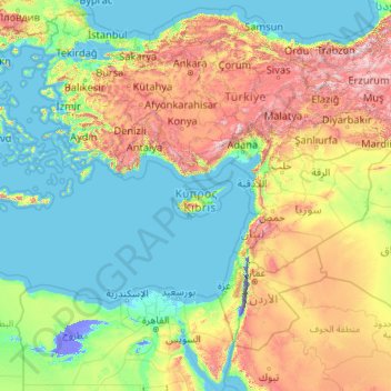
Name: Cyprus topographic map, elevation, terrain.
Location: Cyprus (27.48230 25.64513 42.48230 40.64513)
Average elevation: 1,585 ft
Minimum elevation: -1,362 ft
Maximum elevation: 11,424 ft
Other topographic maps
Click on a map to view its topography, its elevation and its terrain.
Ypsonas Municipality
Cyprus > Cyprus > Kourio Municipality
Ypsonas is built at an altitude of 90 meters. The village area has an inclination from north to south. The altitude decreases from 479 in north to 90 in the village level and to 20 towards southern parts.
Average elevation: 666 ft