
Make a donation
Gear up for your next adventure:
As an Amazon Associate, this site earns from qualifying purchases at no extra cost to you.
Lefke District topographic map
Click on the map to display elevation.
Make a donation
Gear up for your next adventure:
As an Amazon Associate, this site earns from qualifying purchases at no extra cost to you.
About this map
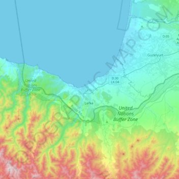
Name: Lefke District topographic map, elevation, terrain.
Location: Lefke District, Northern Cyprus, Cyprus (35.08110 32.59805 35.19302 32.98098)
Average elevation: 902 ft
Minimum elevation: -3 ft
Maximum elevation: 4,537 ft
Make a donation
Gear up for your next adventure:
As an Amazon Associate, this site earns from qualifying purchases at no extra cost to you.
Other topographic maps
Click on a map to view its topography, its elevation and its terrain.
Kyrenia
Another topographical source is the ‘Stadiasmus Maris Magni’ (from the name 'stadion', a unit measuring distances, 1 stadion = 184 metres). The unknown author, who sailed from Cape Anamur on the Cilician coast to Cyprus and circumnavigated the island, gave the distances from Asia Minor to the nearest point…
Average elevation: 381 ft
Make a donation
Gear up for your next adventure:
As an Amazon Associate, this site earns from qualifying purchases at no extra cost to you.
Make a donation
Gear up for your next adventure:
As an Amazon Associate, this site earns from qualifying purchases at no extra cost to you.
Make a donation
Gear up for your next adventure:
As an Amazon Associate, this site earns from qualifying purchases at no extra cost to you.
Make a donation
Gear up for your next adventure:
As an Amazon Associate, this site earns from qualifying purchases at no extra cost to you.
Make a donation
Gear up for your next adventure:
As an Amazon Associate, this site earns from qualifying purchases at no extra cost to you.