
Make a donation
Gear up for your next adventure:
As an Amazon Associate, this site earns from qualifying purchases at no extra cost to you.
Ho Chi Minh City topographic map
Click on the map to display elevation.
Make a donation
Gear up for your next adventure:
As an Amazon Associate, this site earns from qualifying purchases at no extra cost to you.
Ho Chi Minh City
Ho Chi Minh City is located in the south-eastern region of Vietnam, 1,760 km (1,090 mi) south of Hanoi. The average elevation is 5 m (16 ft) above sea level for the city centre and 16 m (52 ft) for the suburb areas.[53] It borders Tây Ninh Province and Bình Dương Province to the north, Đồng Nai Province and Bà Rịa–Vũng Tàu province to the east, Long An Province to the west, Tien Giang Province and East Sea to the south with a coast 15 km (9 mi) long. The city covers an area of 2,095 km2 (809 sq mi or 0.63% of the surface of Vietnam), extending up to Củ Chi District (12 mi or 19 km from the Cambodian border) and down to Cần Giờ on the Eastern Sea. The distance from the northernmost point (Phú Mỹ Hưng Commune, Củ Chi District) to the southernmost one (Long Hòa Commune, Cần Giờ District) is 102 km (63 mi), and from the easternmost point (Long Bình ward, District Nine) to the westernmost one (Bình Chánh Commune, Bình Chánh District) is 47 km (29 mi).[citation needed] Due to its location on the Mekong Delta, the city is fringed by tidal flats that have been heavily modified for agriculture.[54]
Make a donation
Gear up for your next adventure:
As an Amazon Associate, this site earns from qualifying purchases at no extra cost to you.
About this map
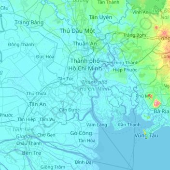
Name: Ho Chi Minh City topographic map, elevation, terrain.
Location: Ho Chi Minh City, Vietnam (8.34569 105.97694 11.50159 108.43112)
Average elevation: 85 ft
Minimum elevation: -10 ft
Maximum elevation: 5,338 ft
Make a donation
Gear up for your next adventure:
As an Amazon Associate, this site earns from qualifying purchases at no extra cost to you.
Other topographic maps
Click on a map to view its topography, its elevation and its terrain.
Ho Chi Minh City
Ho Chi Minh City is located in the south-eastern region of Vietnam, 1,760 km (1,090 mi) south of Hanoi. The average elevation is 5 m (16 ft) above sea level for the city center and 16 m (52 ft) for the suburb areas. It borders Tây Ninh Province and Bình Dương Province to the north, Đồng Nai Province and…
Average elevation: 20 ft
Make a donation
Gear up for your next adventure:
As an Amazon Associate, this site earns from qualifying purchases at no extra cost to you.
Make a donation
Gear up for your next adventure:
As an Amazon Associate, this site earns from qualifying purchases at no extra cost to you.
Huế
Vietnam > Huế > Thuận Hóa Ward
The Perfume River (called Sông Hương or Hương Giang in Vietnamese) passes through the center of the city. The city also accommodates the Tam Giang–Cau Hai lagoon, the largest lagoon in Southeast Asia, which is 68 kilometres (42 mi) long with a surface area of 220 square kilometres (85 sq mi). The city…
Average elevation: 98 ft
Make a donation
Gear up for your next adventure:
As an Amazon Associate, this site earns from qualifying purchases at no extra cost to you.
Make a donation
Gear up for your next adventure:
As an Amazon Associate, this site earns from qualifying purchases at no extra cost to you.
quang truong dai doan ket
Vietnam > Gia Lai Province > Phường Pleiku > Pleiku Ward
Average elevation: 2,477 ft
Make a donation
Gear up for your next adventure:
As an Amazon Associate, this site earns from qualifying purchases at no extra cost to you.
Make a donation
Gear up for your next adventure:
As an Amazon Associate, this site earns from qualifying purchases at no extra cost to you.
Make a donation
Gear up for your next adventure:
As an Amazon Associate, this site earns from qualifying purchases at no extra cost to you.
Make a donation
Gear up for your next adventure:
As an Amazon Associate, this site earns from qualifying purchases at no extra cost to you.
Make a donation
Gear up for your next adventure:
As an Amazon Associate, this site earns from qualifying purchases at no extra cost to you.
Make a donation
Gear up for your next adventure:
As an Amazon Associate, this site earns from qualifying purchases at no extra cost to you.
Make a donation
Gear up for your next adventure:
As an Amazon Associate, this site earns from qualifying purchases at no extra cost to you.
Make a donation
Gear up for your next adventure:
As an Amazon Associate, this site earns from qualifying purchases at no extra cost to you.
Yersin Park
Vietnam > Lâm Đồng Province > Phường Xuân Hương - Đà Lạt > Da Lat
Average elevation: 4,862 ft
Make a donation
Gear up for your next adventure:
As an Amazon Associate, this site earns from qualifying purchases at no extra cost to you.
Ba Den Mountain
Vietnam > Tay Ninh province > Phường Bình Minh
In early December 1974 heavy combat in Tây Ninh began, with People's Army of Vietnam (PAVN) rockets falling on the province capital and on adjacent military installations. The 80-man 3rd Company, 314th Regional Force Battalion guarding the radio relay station on the summit of Nui Ba Den began receiving…
Average elevation: 1,447 ft
Make a donation
Gear up for your next adventure:
As an Amazon Associate, this site earns from qualifying purchases at no extra cost to you.
Make a donation
Gear up for your next adventure:
As an Amazon Associate, this site earns from qualifying purchases at no extra cost to you.
Fansipan Mountain Peak
Vietnam > Lai Chau province > Xã Mường Khoa
Fansipan is the tallest mountain in the Hoang Lien Son range, situated on the border of Lào Cai and Lai Châu provinces, with its peak located on the Lào Cai side. The mountain is part of Hoàng Liên National Park. It has a topographic prominence of 1,617 metres (5,305 ft), ranking sixth in Vietnam.
Average elevation: 8,583 ft
Make a donation
Gear up for your next adventure:
As an Amazon Associate, this site earns from qualifying purchases at no extra cost to you.
Quy Nhơn
Vietnam > Gia Lai Province > Phường Quy Nhơn
Quy Nhon has a varied topography, being extremely diversified with mountains and forests, hills, fields, salt marshes, plains, lagoons, lakes, rivers, shorelines, peninsulas and islands. Its coastline is 42 kilometres or 26 miles long with sandy beaches, abundant seafood resources and other natural products of…
Average elevation: 190 ft
Công Viên Trường Đại Học Phú Yên
Vietnam > Đắk Lắk province > Phường Tuy Hòa > Tuy Hòa
Average elevation: 20 ft
Make a donation
Gear up for your next adventure:
As an Amazon Associate, this site earns from qualifying purchases at no extra cost to you.
Make a donation
Gear up for your next adventure:
As an Amazon Associate, this site earns from qualifying purchases at no extra cost to you.
Make a donation
Gear up for your next adventure:
As an Amazon Associate, this site earns from qualifying purchases at no extra cost to you.
Make a donation
Gear up for your next adventure:
As an Amazon Associate, this site earns from qualifying purchases at no extra cost to you.
Make a donation
Gear up for your next adventure:
As an Amazon Associate, this site earns from qualifying purchases at no extra cost to you.
Make a donation
Gear up for your next adventure:
As an Amazon Associate, this site earns from qualifying purchases at no extra cost to you.
Make a donation
Gear up for your next adventure:
As an Amazon Associate, this site earns from qualifying purchases at no extra cost to you.
Make a donation
Gear up for your next adventure:
As an Amazon Associate, this site earns from qualifying purchases at no extra cost to you.
Make a donation
Gear up for your next adventure:
As an Amazon Associate, this site earns from qualifying purchases at no extra cost to you.