
Make a donation
Gear up for your next adventure:
As an Amazon Associate, this site earns from qualifying purchases at no extra cost to you.
Swoope topographic map
Click on the map to display elevation.
Make a donation
Gear up for your next adventure:
As an Amazon Associate, this site earns from qualifying purchases at no extra cost to you.
About this map
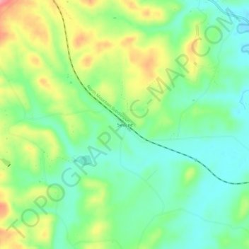
Name: Swoope topographic map, elevation, terrain.
Location: Swoope, Augusta County, Virginia, 24479, United States (38.13819 -79.22642 38.17819 -79.18642)
Average elevation: 1,650 ft
Minimum elevation: 1,526 ft
Maximum elevation: 1,860 ft
Augusta County trails, hiking, mountain biking, running and outdoor activities
Make a donation
Gear up for your next adventure:
As an Amazon Associate, this site earns from qualifying purchases at no extra cost to you.
Other topographic maps
Click on a map to view its topography, its elevation and its terrain.
Make a donation
Gear up for your next adventure:
As an Amazon Associate, this site earns from qualifying purchases at no extra cost to you.
Natural Chimneys Park & Campground
United States > Virginia > Augusta County
Average elevation: 1,381 ft
Make a donation
Gear up for your next adventure:
As an Amazon Associate, this site earns from qualifying purchases at no extra cost to you.
Stuarts Draft
United States > Virginia > Augusta County
Stuarts Draft includes several natural and man-made ponds. Lake Wilda is Green Pond is a naturally occurring high-elevation pond on the Big Levels Ridge. It is five acres in size during the wet season. The Virginia Commission of Game and Inland Fisheries constructed the Maple Flats Ponds in the late 1950s to…
Average elevation: 1,503 ft