Geolocate

Pristina topographic map

Click on the map to display elevation.

About this map

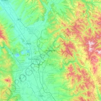
Name: Pristina topographic map, elevation, terrain.

Location: Pristina, Municipality of Pristina, 10000, Kosovo (42.50388 21.00408 42.82388 21.32408)

Average elevation: 2,280 ft

Minimum elevation: 1,575 ft

Maximum elevation: 4,022 ft

Other topographic maps

Click on a map to view its topography, its elevation and its terrain.

Lakrishtë

Kosovo > Municipality of Pristina > Pristina

Average elevation: 1,978 ft

Qyteza Pejton

Kosovo > Municipality of Pristina > Pristina

Average elevation: 1,998 ft

Gear up for your next adventure:

🥇GPS Hiking Watch - Multi‑sport GPS watch with navigation and trail tracking
Solar GPS Watches - Advanced multisport watches with built-in topographic maps
🔦Powerful Headlamps - Ultra-bright hands-free lighting for night navigation
🛡️Insect Repellent - Protection against bugs during outdoor activities
🧭Hiking Compass - Precision compass for reliable navigation in the wilderness

As an Amazon Associate, this site earns from qualifying purchases at no extra cost to you.