
Make a donation
Gear up for your next adventure:
As an Amazon Associate, this site earns from qualifying purchases at no extra cost to you.
Bozeman topographic map
Click on the map to display elevation.
Gear up for your next adventure:
As an Amazon Associate, this site earns from qualifying purchases at no extra cost to you.
Bozeman
Bozeman is located at an elevation of 4,820 feet (1,470 m). The Bridger Mountains are to the north-northeast, the Tobacco Root Mountains to the west-southwest, the Big Belt Mountains and Horseshoe Hills to the northwest, the Hyalite Peaks of the northern Gallatin Range to the south and the Spanish Peaks of the northern Madison Range to the south-southwest. Bozeman is east of the continental divide, and Interstate 90 passes through the city. It is 84 miles (135 km) east of Butte, 125 miles (201 km) west of Billings, and 93 miles (150 km) north of Yellowstone National Park.
Make a donation
Gear up for your next adventure:
As an Amazon Associate, this site earns from qualifying purchases at no extra cost to you.
About this map
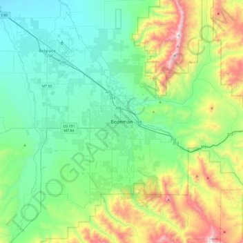
Name: Bozeman topographic map, elevation, terrain.
Location: Bozeman, Gallatin County, Montana, 59715, United States (45.51943 -111.20405 45.83943 -110.88405)
Average elevation: 5,509 ft
Minimum elevation: 4,281 ft
Maximum elevation: 9,081 ft
Gallatin County trails, hiking, mountain biking, running and outdoor activities
Make a donation
Gear up for your next adventure:
As an Amazon Associate, this site earns from qualifying purchases at no extra cost to you.
Other topographic maps
Click on a map to view its topography, its elevation and its terrain.