
Oakland topographic map
Interactive map
Click on the map to display elevation.
About this map
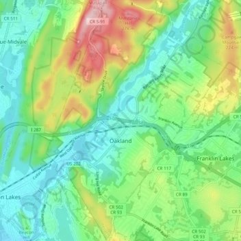
Name: Oakland topographic map, elevation, terrain.
Location: Oakland, Bergen County, New Jersey, 07436, United States (40.99209 -74.27248 41.06382 -74.20177)
Average elevation: 436 ft
Minimum elevation: 187 ft
Maximum elevation: 974 ft
Bergen County trails, hiking, mountain biking, running and outdoor activities
Other topographic maps
Click on a map to view its topography, its elevation and its terrain.
Hillsdale
United States > New Jersey > Bergen County > Hillsdale > Hillsdale
Average elevation: 131 ft
Ridgefield Park
United States > New Jersey > Bergen County > Ridgefield Park > Ridgefield Park
Average elevation: 69 ft
Glen Rock
United States > New Jersey > Bergen County > Glen Rock > Glen Rock
Average elevation: 171 ft