
Hampden topographic map
Interactive map
Click on the map to display elevation.
About this map
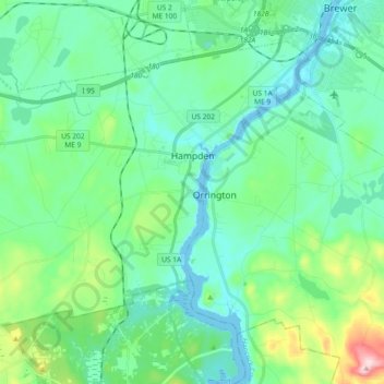
Name: Hampden topographic map, elevation, terrain.
Location: Hampden, Penobscot County, Maine, 04444, United States (44.68068 -68.96519 44.78339 -68.78128)
Average elevation: 174 ft
Minimum elevation: -20 ft
Maximum elevation: 833 ft
Penobscot County trails, hiking, mountain biking, running and outdoor activities
Other topographic maps
Click on a map to view its topography, its elevation and its terrain.