
Make a donation
Gear up for your next adventure:
As an Amazon Associate, this site earns from qualifying purchases at no extra cost to you.
Ravenna Township topographic map
Click on the map to display elevation.
Make a donation
Gear up for your next adventure:
As an Amazon Associate, this site earns from qualifying purchases at no extra cost to you.
About this map
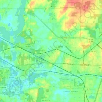
Name: Ravenna Township topographic map, elevation, terrain.
Location: Ravenna Township, Portage County, Ohio, United States (41.13471 -81.30068 41.20240 -81.19261)
Average elevation: 1,096 ft
Minimum elevation: 1,030 ft
Maximum elevation: 1,214 ft
Portage County trails, hiking, mountain biking, running and outdoor activities
Make a donation
Gear up for your next adventure:
As an Amazon Associate, this site earns from qualifying purchases at no extra cost to you.
Other topographic maps
Click on a map to view its topography, its elevation and its terrain.
Little Mussy Lake
United States > Ohio > Portage County > Rootstown Township
Average elevation: 1,083 ft
Make a donation
Gear up for your next adventure:
As an Amazon Associate, this site earns from qualifying purchases at no extra cost to you.