
Make a donation
Gear up for your next adventure:
As an Amazon Associate, this site earns from qualifying purchases at no extra cost to you.
Gold Camp topographic map
Click on the map to display elevation.
Make a donation
Gear up for your next adventure:
As an Amazon Associate, this site earns from qualifying purchases at no extra cost to you.
About this map
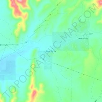
Name: Gold Camp topographic map, elevation, terrain.
Location: Gold Camp, Pinal County, Arizona, United States (33.27367 -111.32429 33.31367 -111.28429)
Average elevation: 2,077 ft
Minimum elevation: 1,932 ft
Maximum elevation: 2,497 ft
Pinal County trails, hiking, mountain biking, running and outdoor activities
Make a donation
Gear up for your next adventure:
As an Amazon Associate, this site earns from qualifying purchases at no extra cost to you.
Other topographic maps
Click on a map to view its topography, its elevation and its terrain.
Kearny
United States > Arizona > Pinal County
Kearny Airport is a general aviation airport located in the southern section of the town. In 2003 it received the Arizona Department of Transportation's Airport of the Year award. The airport has a single asphalt runway, 3,400 feet (1,000 m) in length and 60 feet (18 m) in width, with a field elevation of…
Average elevation: 1,896 ft
San Manuel
United States > Arizona > Pinal County
San Manuel is located at 32°36′18″N 110°38′0″W / 32.60500°N 110.63333°W / 32.60500; -110.63333 (32.605048, -110.633340), in the San Pedro River Valley at an elevation of about 3,500 feet (1,100 m). San Manuel is approximately 45 miles (72 km) northeast of Tucson.
Average elevation: 3,251 ft
Make a donation
Gear up for your next adventure:
As an Amazon Associate, this site earns from qualifying purchases at no extra cost to you.
Make a donation
Gear up for your next adventure:
As an Amazon Associate, this site earns from qualifying purchases at no extra cost to you.