
Make a donation
Gear up for your next adventure:
As an Amazon Associate, this site earns from qualifying purchases at no extra cost to you.
Blue Mountains topographic map
Click on the map to display elevation.
Gear up for your next adventure:
As an Amazon Associate, this site earns from qualifying purchases at no extra cost to you.
Blue Mountains
A sandstone plateau dominated by a landscape of endless eucalyptus forests, the Blue Mountains are located at the top of a 470-million-year-old quartzite. In the Permian period, a shallow sea covered the region, when rivers brought shales, siltstones and mudstones. Then during the Mesozoic period, rivers dumped vast amounts of sand, burying the other sedimentary rocks. By about 1 million years ago during the Pliocene era, the Blue Mountains began to form, carving out deep valleys and steep cliffs, with an elevation of 3,900 feet. Its main distinctive natural feature are the Three Sisters, a formation of triple sandstone peaks scoured by erosion, whose rocks are lit by the glimpse of light at the time of day.
Make a donation
Gear up for your next adventure:
As an Amazon Associate, this site earns from qualifying purchases at no extra cost to you.
About this map
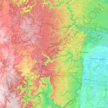
Name: Blue Mountains topographic map, elevation, terrain.
Location: Blue Mountains, New South Wales, Australia (-33.95532 150.12817 -33.17894 150.68710)
Average elevation: 1,857 ft
Minimum elevation: 3 ft
Maximum elevation: 4,432 ft
Make a donation
Gear up for your next adventure:
As an Amazon Associate, this site earns from qualifying purchases at no extra cost to you.
Other topographic maps
Click on a map to view its topography, its elevation and its terrain.
Make a donation
Gear up for your next adventure:
As an Amazon Associate, this site earns from qualifying purchases at no extra cost to you.
Hazelbrook
Australia > New South Wales > Sydney
Hazelbrook is a town in New South Wales, Australia (Elevation: 675 metres) It is located 91 kilometres west of Sydney and 16 kilometres east of Katoomba in the Blue Mountains on the Great Western Highway.
Average elevation: 2,001 ft
Make a donation
Gear up for your next adventure:
As an Amazon Associate, this site earns from qualifying purchases at no extra cost to you.
Make a donation
Gear up for your next adventure:
As an Amazon Associate, this site earns from qualifying purchases at no extra cost to you.
Make a donation
Gear up for your next adventure:
As an Amazon Associate, this site earns from qualifying purchases at no extra cost to you.
Make a donation
Gear up for your next adventure:
As an Amazon Associate, this site earns from qualifying purchases at no extra cost to you.
Make a donation
Gear up for your next adventure:
As an Amazon Associate, this site earns from qualifying purchases at no extra cost to you.
Make a donation
Gear up for your next adventure:
As an Amazon Associate, this site earns from qualifying purchases at no extra cost to you.
Make a donation
Gear up for your next adventure:
As an Amazon Associate, this site earns from qualifying purchases at no extra cost to you.
Make a donation
Gear up for your next adventure:
As an Amazon Associate, this site earns from qualifying purchases at no extra cost to you.
Make a donation
Gear up for your next adventure:
As an Amazon Associate, this site earns from qualifying purchases at no extra cost to you.
Make a donation
Gear up for your next adventure:
As an Amazon Associate, this site earns from qualifying purchases at no extra cost to you.
Make a donation
Gear up for your next adventure:
As an Amazon Associate, this site earns from qualifying purchases at no extra cost to you.
Make a donation
Gear up for your next adventure:
As an Amazon Associate, this site earns from qualifying purchases at no extra cost to you.
Make a donation
Gear up for your next adventure:
As an Amazon Associate, this site earns from qualifying purchases at no extra cost to you.
Make a donation
Gear up for your next adventure:
As an Amazon Associate, this site earns from qualifying purchases at no extra cost to you.
Make a donation
Gear up for your next adventure:
As an Amazon Associate, this site earns from qualifying purchases at no extra cost to you.
Make a donation
Gear up for your next adventure:
As an Amazon Associate, this site earns from qualifying purchases at no extra cost to you.
Make a donation
Gear up for your next adventure:
As an Amazon Associate, this site earns from qualifying purchases at no extra cost to you.
Sydney
Phillip had been given no instructions for urban development, but in July 1788 submitted a plan for the new town at Sydney Cove. It included a wide central avenue, a permanent Government House, law courts, hospital and other public buildings, but no provision for warehouses, shops, or other commercial…
Average elevation: 105 ft
Make a donation
Gear up for your next adventure:
As an Amazon Associate, this site earns from qualifying purchases at no extra cost to you.
Make a donation
Gear up for your next adventure:
As an Amazon Associate, this site earns from qualifying purchases at no extra cost to you.