
Lutz topographic map
Interactive map
Click on the map to display elevation.
About this map
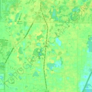
Name: Lutz topographic map, elevation, terrain.
Location: Lutz, Hillsborough County, Florida, 33548, United States (28.11112 -82.50148 28.19112 -82.42148)
Average elevation: 69 ft
Minimum elevation: 36 ft
Maximum elevation: 102 ft
Hillsborough County trails, hiking, mountain biking, running and outdoor activities
Other topographic maps
Click on a map to view its topography, its elevation and its terrain.
City of Tampa Waterworks Dam
United States > Florida > Hillsborough County > Tampa > Altos Verdes
Average elevation: 43 ft
Alafia Scrub Nature Preserve
United States > Florida > Hillsborough County > Riverview
Average elevation: 33 ft
Dover
United States > Florida > Hillsborough County > Brandon > Aarons Place
Average elevation: 108 ft
Egypt Lake-Leto
United States > Florida > Hillsborough County
Egypt Lake-Leto is located in northwestern Hillsborough County at 28°0′55″N 82°30′26″W / 28.01528°N 82.50722°W / 28.01528; -82.50722 (28.015396, -82.507311), 7 miles (11 km) northwest of downtown Tampa. The elevation for the CDP is 45 feet (14 m) above sea level.
Average elevation: 49 ft