
Make a donation
Gear up for your next adventure:
As an Amazon Associate, this site earns from qualifying purchases at no extra cost to you.
Chennai topographic map
Click on the map to display elevation.
Make a donation
Gear up for your next adventure:
As an Amazon Associate, this site earns from qualifying purchases at no extra cost to you.
Chennai
Chennai is located on the south–eastern coast of India in the north–eastern part of Tamil Nadu on a flat coastal plain known as the Eastern Coastal Plains. Its average elevation is around 6.7 metres (22 ft), and its highest point is 60 m (200 ft). Chennai is 2,184 kilometres (1,357 mi) south of Delhi, 1,337 kilometres (831 mi) southeast of Mumbai, and 1,707 kilometres (1,061 mi) southwest of Kolkata by road. Two major rivers flow through Chennai, the Cooum River (or Koovam) through the centre and the Adyar River to the south. A third river, the Kortalaiyar, travels through the northern fringes of the city before draining into the Bay of Bengal, at Ennore. The estuary of this river is heavily polluted with effluents released by the industries in the region. Adyar and Cooum rivers are heavily polluted with effluents and waste from domestic and commercial sources, the Coumm being so heavily polluted it is regarded as the city's eyesore. A protected estuary on the Adyar forms a natural habitat for several species of birds and animals. The Buckingham Canal, 4 km (2.5 mi) inland, runs parallel to the coast, linking the two rivers. The Otteri Nullah, an east–west stream, runs through north Chennai and meets the Buckingham Canal at Basin Bridge. Several lakes of varying size are located on the western fringes of the city. Some areas of the city have the problem of excess iron content in groundwater.
Make a donation
Gear up for your next adventure:
As an Amazon Associate, this site earns from qualifying purchases at no extra cost to you.
About this map
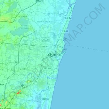
Name: Chennai topographic map, elevation, terrain.
Location: Chennai, Tamil Nadu, 600001, India (12.92369 80.11019 13.24369 80.43019)
Average elevation: 23 ft
Minimum elevation: -7 ft
Maximum elevation: 466 ft
Make a donation
Gear up for your next adventure:
As an Amazon Associate, this site earns from qualifying purchases at no extra cost to you.
Other topographic maps
Click on a map to view its topography, its elevation and its terrain.
Chennai
Chennai is located on the southeastern coast of India in the northeastern part of Tamil Nadu on a flat coastal plain known as the Eastern Coastal Plains with an average elevation of 6.7 m (22 ft) and highest point at 60 m (200 ft). Chennai's soil is mostly clay, shale and sandstone. Clay underlies most of the…
Average elevation: 26 ft
Kanniyakumari
Kanyakumari district has a varied topography with sea on three sides and the mountains of the Western Ghats bordering the northern side. Except for a small stretch of land to the west of Kanyakumari town, almost the entire district is sandwiched between the Western Ghats and the Arabian Sea - the only district…
Average elevation: 741 ft
Make a donation
Gear up for your next adventure:
As an Amazon Associate, this site earns from qualifying purchases at no extra cost to you.
Madurai
India > Tamil Nadu > Madurai
Madurai is located at 9°56′N 78°07′E / 9.93°N 78.12°E / 9.93; 78.12. It has an average elevation of 101 metres. The city of Madurai lies on the flat and fertile plain of the river Vaigai, which runs in the northwest-southeast direction through the city, dividing it into two almost equal…
Average elevation: 453 ft
Make a donation
Gear up for your next adventure:
As an Amazon Associate, this site earns from qualifying purchases at no extra cost to you.
Nilgiris
The district has an area of 2,552.50 km2. The district is basically hilly, lying at an elevation of 1,000 to 2,600 metres above MSL, and divided between the Nilgiri plateau and the lower, smaller Wayanad plateau. The district lies at the juncture of the Western Ghats and the Eastern Ghats. Its latitudinal and…
Average elevation: 3,199 ft
Coimbatore
Apart from the species common to the plains, wild elephants, wild boars leopards, tigers, bison, species of deer, Nilgiri tahr, sloth bear and black-headed oriole can be found. The Anamalai Wildlife Sanctuary 88 km (55 mi) in the Western Ghats at an altitude of 1,400 meters covers an area of 958 km2. More than…
Average elevation: 1,808 ft
Make a donation
Gear up for your next adventure:
As an Amazon Associate, this site earns from qualifying purchases at no extra cost to you.
Make a donation
Gear up for your next adventure:
As an Amazon Associate, this site earns from qualifying purchases at no extra cost to you.
Make a donation
Gear up for your next adventure:
As an Amazon Associate, this site earns from qualifying purchases at no extra cost to you.
Vellore
Yelagiri is a hill station located in Tirupattur district of the Vaniyambadi-Tirupattur road at an altitude of 1,410.6 metres above mean sea level and spread across 30 km2.
Average elevation: 1,145 ft
Kovilpatti
India > Tamil Nadu > Kovilpatti
Kovilpatti is located in South India. It has an average elevation of 101 meters (334 ft).
Average elevation: 318 ft
Make a donation
Gear up for your next adventure:
As an Amazon Associate, this site earns from qualifying purchases at no extra cost to you.
Make a donation
Gear up for your next adventure:
As an Amazon Associate, this site earns from qualifying purchases at no extra cost to you.
Zone 14 Perungudi
India > Tamil Nadu > Sholinganallur > Chennai
Perungudi is located at 12°58′N 80°15′E / 12.97°N 80.25°E / 12.97; 80.25. It has an average elevation of 9 metres (29 feet).
Average elevation: 10 ft
Karambakkudi
India > Tamil Nadu > Karambakudi taluk
This area is in the protected agricultural zone of the Cauvery Delta. Karambakkudi is located at 10°28′N 79°08′E / 10.47°N 79.13°E / 10.47; 79.13. It has an average elevation of 36 metres (118 feet).
Average elevation: 154 ft
Make a donation
Gear up for your next adventure:
As an Amazon Associate, this site earns from qualifying purchases at no extra cost to you.
Bargur
India > Tamil Nadu > Bargur
Bargur is spread over an area of 22.50 square kilometres (8.69 sq mi) of land in the northeast of Krishnagiri district, at 12°32′33″N 78°21′26″E / 12.5425°N 78.3572°E / 12.5425; 78.3572, at an average elevation of 532 metres (1,745 ft) above sea level. It is about 15 kilometres (9.3 mi)…
Average elevation: 1,611 ft
Make a donation
Gear up for your next adventure:
As an Amazon Associate, this site earns from qualifying purchases at no extra cost to you.
Make a donation
Gear up for your next adventure:
As an Amazon Associate, this site earns from qualifying purchases at no extra cost to you.
Erode
The topography of the district consists of plains sloping from rom north east to south west. The Eastern Ghats run through the north-western part of the district, and is straddled by the Western Ghats in the west, with the mountain ranges separated by the Moyar River. The region comprises the high altitude…
Average elevation: 1,680 ft
Make a donation
Gear up for your next adventure:
As an Amazon Associate, this site earns from qualifying purchases at no extra cost to you.
Nagapattinam District
The district shares borders with Tiruvarur district of Tamil Nadu and Karaikal district of the union territory Puducherry. The district of Nagapattinam lies on the shores of the Bay of Bengal between latitude 10.7906°N and Longitude 79.8428°E an area of 1,397 square kilometres (539 sq mi). The District…
Average elevation: 13 ft
Make a donation
Gear up for your next adventure:
As an Amazon Associate, this site earns from qualifying purchases at no extra cost to you.
Chennai
Chennai is located on the southeastern coast of India in the northeastern part of Tamil Nadu on a flat coastal plain known as the Eastern Coastal Plains with an average elevation of 6.7 m (22 ft) and highest point at 60 m (200 ft). Chennai's soil is mostly clay, shale and sandstone. Clay underlies most of the…
Average elevation: 26 ft
Chembrampakkam Surplus to Adayar
India > Tamil Nadu > Pallavaram > Tiruneermalai
Average elevation: 66 ft
Make a donation
Gear up for your next adventure:
As an Amazon Associate, this site earns from qualifying purchases at no extra cost to you.
Make a donation
Gear up for your next adventure:
As an Amazon Associate, this site earns from qualifying purchases at no extra cost to you.
Nilgiris
The district has an area of 2,552.50 km2. The district is basically hilly, lying at an elevation of 1,000 to 2,600 metres above MSL, and divided between the Nilgiri plateau and the lower, smaller Wayanad plateau. The district lies at the juncture of the Western Ghats and the Eastern Ghats. Its latitudinal and…
Average elevation: 3,199 ft
Make a donation
Gear up for your next adventure:
As an Amazon Associate, this site earns from qualifying purchases at no extra cost to you.
Erode
Western Ghats runs through the district and it is straddled by Eastern Ghats which is separated by Moyar River. The region comprises the high altitude regions of the north sloping gently towards a long undulating plain in the south. Bhavani River cuts the district roughly in the middle, flowing from west to…
Average elevation: 1,680 ft
Make a donation
Gear up for your next adventure:
As an Amazon Associate, this site earns from qualifying purchases at no extra cost to you.
Tirunelveli
India > Tamil Nadu > Tirunelveli
Tirunelveli is located at 8°43′41.82″N 77°41′43.94″E / 8.7282833°N 77.6955389°E / 8.7282833; 77.6955389, and its average elevation is 47 metres (154 ft). It is located at the southernmost tip of the Deccan plateau. The Tamirabarani River divides the city into the Tirunelveli quarter and…
Average elevation: 157 ft
Make a donation
Gear up for your next adventure:
As an Amazon Associate, this site earns from qualifying purchases at no extra cost to you.
Chennai
Chennai is located on the southeastern coast of India in the northeastern part of Tamil Nadu on a flat coastal plain known as the Eastern Coastal Plains with an average elevation of 6.7 m (22 ft) and highest point at 60 m (200 ft). Chennai's soil is mostly clay, shale and sandstone. Clay underlies most of the…
Average elevation: 26 ft
Make a donation
Gear up for your next adventure:
As an Amazon Associate, this site earns from qualifying purchases at no extra cost to you.
Dharapuram
India > Tamil Nadu > Dharapuram
Dharapuram is located at 10°44′N 77°31′E / 10.73°N 77.52°E / 10.73; 77.52. Dharapuram town is situated along of the bank of Amaravathi River which flows from the south to north. Uppar River and dam, Nallathankal River and dam, Palar join the river Amaravathi. It has an average elevation of 45…
Average elevation: 827 ft
Thiruvallur
The northern taluks of the district like Ponneri, Uttukkottai, Gummidipundi etc. do not have much to offer from the scenic point of view. In the Tiruttani taluk, a number of hillocks are found scattered. The soil of the district is mostly sandy, mixed with soda or other alkali or stony. Rocks found in and near…
Average elevation: 164 ft
Make a donation
Gear up for your next adventure:
As an Amazon Associate, this site earns from qualifying purchases at no extra cost to you.
Make a donation
Gear up for your next adventure:
As an Amazon Associate, this site earns from qualifying purchases at no extra cost to you.
Make a donation
Gear up for your next adventure:
As an Amazon Associate, this site earns from qualifying purchases at no extra cost to you.
Make a donation
Gear up for your next adventure:
As an Amazon Associate, this site earns from qualifying purchases at no extra cost to you.
Kodaikanal
India > Tamil Nadu > Kodaikanal
Kodaikanal (Tamil: [ko'ɖaɪ'kaːnəl]) (English: ko-DYE-KAH-null) is a municipality and hill station in Dindigul district in the state of Tamil Nadu, India. It is situated at an altitude of 2,225 m (7,300 ft) in the Palani hills of the Western Ghats. Kodaikanal was established in 1845 to serve as a refuge…
Average elevation: 6,483 ft
Make a donation
Gear up for your next adventure:
As an Amazon Associate, this site earns from qualifying purchases at no extra cost to you.
Make a donation
Gear up for your next adventure:
As an Amazon Associate, this site earns from qualifying purchases at no extra cost to you.
Make a donation
Gear up for your next adventure:
As an Amazon Associate, this site earns from qualifying purchases at no extra cost to you.